The Continental
|
|
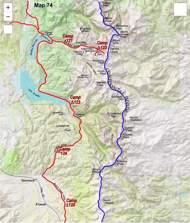
October 13th - 15th Rocky Mtn Ntl Pk, CO (Go to Pt 1) I sat in the meadow for quite some time, feeling mentally crushed and completely defeated. I was still feeling the shaky aftershock of having had to confront mortality up in the gully and I was pretty convinced at this point that I just wanted to hike out of the mountains and get on a bus back to St. Louis. Resigned to failure, I finally shouldered my load at around one in the afternoon and started down the East Inlet drainage to Grand Lake. By the time I got down to Lake Verna I was back on a friendly trail gazing out at what was an undeniably gorgeous afternoon, reminding me that afternoons like this were worth being out here for. As I hiked the last few miles to town, Mexico guy, who had been sitting quietly on the sidelines for the last couple of days, observed how pleasant it was to be hiking on a trail and how nice the warmer temperatures were, now that we had dropped into the lower valley. Yes, I had to agree, it was all pretty nice. Then the Mexico guy started to question why I was giving-up on the trip while options were still available. Once in town and back at the same motel from several nights ago, I dumped my pack in the room with a splitting argument going on in my head. First off, the Divide guy had already cashed out and was ready to leave. His perspective said that getting across these mountains at this time of year, by myself, was beyond my capabilities and when I’d shouldered my pack at Spirit Lake earlier in the afternoon, my unchallenged plan at that point had been to hike out and go home. However, and boosted by the mirage of some kind of endless, Indian-summer, the hike out had been too pleasant to ignore and now I wasn’t all that sure I did want to quit. The side of me that kept saying ‘let’s just get to Mexico’ was irritated that I was thinking about cancelling the whole trip just because the ‘grandiose Divide guy’ couldn’t do his job; I didn’t have to quit, I just needed to change tactics. But my more principled side, which was the Divide guy, was the part struggling with what I had originally committed to, which was the Continental Divide, and how I would feel about this trip if I were to continue on without Rocky Mountain National Park and the high peaks along the Continental Divide that came afterward. This trip, as originally conceived, really was over. As the Clash once asked, “Should I stay or should I go?” The arguing and confusion in my brain was about enough to make me weep. A decision needed to be made, like right now, and I couldn’t do it. So, in defiance of any decision, I pulled out the Hobbit book and began to read like a believer. If I had gotten-up the next morning to cold, crappy weather, I probably would have found an eastbound bus and left. Instead, it was a crisp, autumn day with blue skies, “to infinity and beyond,” and Mexico guy was up early asking ‘why quit?’ A perfectly good trail lay just beyond the motel room door and just because it followed out the sprawling valley, many miles away from the Continental Divide, didn’t necessarily condemn it as unworthy to the overall goal. The Divide guy, though, who had gotten up in the morning with the only thought of going home, had now become my mental pessimist toward this lowland tactic. For instance, I didn’t have maps for this valley, or any other low-lying valley that far away from the Continental Divide, so how, exactly, did I plan to navigate?
“Alright, godamit!” I decided to give it a go to Georgetown with the caveat that if things turned into a floundering fiasco because I didn’t have the right maps, or if the weather turned hard against me… then Georgetown would probably be it. Before my thought process had a chance to do another debate backflip, I grabbed my pack and headed out the door for the Shadow Mountain Lake trail. As would be the case, I got screwed-up right off the bat trying to find the trailhead and ended up cursing my way through a number of backyards on the east side of Grand Lake until I finally got past the private property and found the lake trail. Once I got moving along the trail and with no more immediate decisions to be made, I started to think more about how I was walking away from Rocky Mountain National Park without having seen much of the legendary Never Summer Range or Front Range peaks, and for this I had plenty of time to consider since time spent along an easy path like this was a pretty deep dive into the idle mind. Most of my mindless wanderings were harmless, maybe the occasional skewer toward gloom and doom or overzealous optimism, but today was different. As I walked away from Rocky Mountain National Park my idle, trail thoughts had me looking skeptically at both the Divide guy and the Mexico guy, leaving me to question ‘Who the heck am I?’ Then I tried to define what it was that I was actually trying to gain from this experience; was it identity? And that led to an attempt to gauge the value of this trip without having traversed through Rocky Mountain National Park. Then I wondered, was it prudence that led me to avoid the National Park or just plain fear and mental weakness? Then my idle mind seized on ‘what are people going to think when they find out I dodged Rocky Mountain National Park?’ And this was a really shitty place to go, letting other people into my head to ridicule me for this glaring omission with variations of self-discrediting mockery plaguing my thoughts the rest of the afternoon. By the time I had reached a place to camp near the inlet to Lake Granby, my idle mind had joined forces with the Divide guy to drag me down into being an outright fraud by comparing what I had told everyone I was going to do with what I was actually doing. I mean, sure, the grand illusion of tip-toeing a tightrope along the Continental Divide had long since been demolished, but in the Wind River Range in Wyoming, and through other difficult ranges in Montana, Craig and I had always maintained at least a respectable line through the mountains, whereas now I had just come out of one of this country’s premier National Parks, one people were sure to ask about, having done practically no route at all. How was I going to account for that? {Side Note: The Continental Divide Trail system, as it stands today, follows much of this same route along the Shadow Mountain Lake/Lake Granby trail, short looping into the National Park by a different route than mine but similar to what I had done, and more notably, the CDT doesn’t attempt to traverse the Front Range peaks or go up into the Never Summer Range, either. In 1977, though, this dodge felt to me like copping-out on myself.} I camped in an empty campground near the inlet to Lake Granby with the 13,000ft ridgeline of the Continental Divide nearly seven miles off to the east and almost 5,000 feet higher in elevation than my campsite. For maps I was carrying a 250,000 series topo showing me the overall lay of the land, but I was west of the detailed, 24,000 series maps I carried and I didn’t know by how much. In the morning, I took the maps I was carrying and wandered over to a large National Park map posted near the bathrooms showing the trails leading out from the campground. I could see from the campground map that Monarch Lake was only about a mile further up the inlet from where I was and one of my detailed, 24,000 series maps also showed Monarch Lake, so I decided Monarch Lake was a good place to start. A fairly easy hike brought me up to and around Monarch Lake where at the inlet I again had to choose between two trails. The Arapahoe Pass trail, which climbed back up into a cirque below the Continental Divide or the Mill Creek trail which climbed about 1,200 vertical feet up onto a sprawling ridge just west of the Divide. The Arapahoe Pass trail, like the East Inlet trail, would probably require winter mountaineering equipment to climb back out of, while the Mill Creek trail was going to run off the edge of my detailed, topo map once I got on top of the ridge. Mm… do I risk getting lost or getting killed? Knowing what was waiting for me if I went up the Arapahoe Pass trail, I decided to climb up Mill Creek to the ridge and wing-it from there. Several hours of uphill grind later, I came out to Sawmill Meadows at the top of the ridge where I stopped for lunch in the meadow. I could see a dirt road coming across from the other side, making the area accessible to vehicles; I didn’t see any vehicles, just a primary dirt road and a few jeep tracks. I munched at my lunch while studying the 250,000 series map until it was clear that the only useable information the map was going to provide me was that Hwy 40 and Berthoud Pass were southwest of my current location, and that I already knew. It was always the same with these prick-teaser 250,000s. No matter how hard I looked, they just never offered up the navigational details I needed for wilderness travel because the details were always lost in the map’s 40,000 foot overview of the landscape. I wasted a lot of time that afternoon just dithering over the maps, almost paralyzed by indecision, or more accurately, paralyzed by the only decision I felt I could make, which was to follow this dirt road down to Hwy 40 then turn south and start walking up the pavement to Berthoud Pass. The highway, the fucking highway, that’s where this was all going to end up and there was not a single personality roaming around in my head that wanted to go backpacking on a state highway, not even the Mexico guy.
0 Comments
Leave a Reply. |
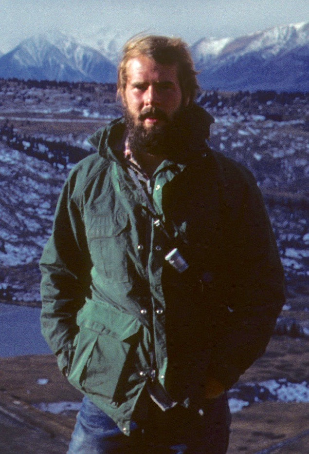
Kip RuskIn 1977, Kip Rusk walked a route along the Continental Divide from Canada to Mexico. His nine month journey is one of the first, documented traverses of the US Continental Divide. Montana Part 1 - Glacier Ntl Pk Part 2 - May 11 Part 3 - May 15 Part 4 - May 19 Part 5 - May 21 Part 6 - May 24 Part 7 - May 26 Part 8 - June 2 Part 9 - June 5 Part 10 - June 7 Part 11 - June 8 Part 12 - June 11 Part 13 - June 12 Part 14 - June 15 Part 15 - June 19 Part 16 - June 23 Part 17 - June 25 Part 18 - June 27 Part 19 - June 30 Part 20 - July 5-6 Part 21 - July 7-8 Part 22 - July 9-10 Part 23 - July 11-15 Part 24 - July 17-18 Part 25 - July 18-19 Part 26 - July 19 Part 27 - July 20-21 Part 28 - July 22-23 Part 29 - July 24-26 Part 30 - July 26-30 Part 31 - July 31-Aug 1 Part 32 - Aug 1-4 Part 33 - Aug 4-6 Part 34 - Aug 6 Part 35 - Aug 7-9 Part 36 - Aug 9-10 Part 37 - Aug 10-13 Wyoming Part 38 - Aug 14 Part 39 - Aug 15-16 Part 40 - Aug 16-18 Part 41 - Aug 19-21 Part 42 - Aug 20-22 Part 43 - Aug 23-25 Part 44 - Aug 26-28 Part 45 - Aug 28-29 Part 46 - Aug 29-31 Part 47 - Sept 1-3 Part 48 - Sept 4-5 Part 49 - Sept 5-6 Part 50 - Sept 6-7 Part 51 - Sept 8-10 Part 52 - Sept 11-13 Part 53 - Sept 13-16 Part 54 - Sept 17-19 Part 55 --Sept 19-21 Part 56 Sept 21-23 Part 57 - Sept 23-25 Part 58 - Sept 26-26 Colorado Part 59 - Sept 26 Part 60 - Sept 30-Oct 3 Part 61 - Oct 3 Part 62 - Oct 4-6 Part 63 - Oct 6-7 Part 64 - Oct 8-10 Part 65 - Oct 10-12 Part 66 - Oct 11-13 Part 67 - Oct 13-15 Part 68 - Oct 15-19 Part 69 - Oct 21-23 Part 70 - Oct 23-28 Part 71 - Oct 27-Nov 3 Part 72 - Nov 3-5 Part 73 - Nov 6-8 Part 74 - Nov 9-17 Part 75 - Nov 19-20 Part 76 - Nov 21-26 Part 77 - Nov 26-30 Part 78 - Dec 1-3 New Mexico Part 79 - Dec 3-7 Part 80 - Dec 8-11 Part 81 - Dec 12-14 Part 82 - Dec 14-22 Part 83 - Dec 23-28 Part 84 - Dec 28-31 Part 85 - Dec 31-Jan2 Part 86 - Jan 2-6 Part 87 - Jan 6-12 Part 88 - Jan 12-13 Part 89 - Jan 13-16 Part 90 - Jan 16-17 Part 91 - Jan 17 End |
© Copyright 2025 Barefoot Publications, All Rights Reserved


