Rocky Mountain Day Hikes
  • Home
  • Hike Rocky Magazine
    • Hike Rocky magazine
    • RMNP Updates
    • Trail Reviews
    • Gear Reviews
    • Science & Ecology
    • History & Current Issues
    • Stories & Adventure
    • Culture and Arts in the Park
    • The Continental Divide Story, 1977 by Kip Rusk
  • Trail Guide to RMNP
    • Trails by Location
    • Trails by Distance
    • Trails by Destination
    • Index of Trails
  • Wildflowers of RMNP
    • April/May Flowers
    • June/July Flowers
    • August/September Flowers
  • About Us
    • Who We Are
    • Supporting Partners
    • Media Kit
    • 2025 Hike Rocky Print Edition
    • 2024 Hike Rocky Print Magazine

The Continental
Divide Story, 1977
​by Kip Rusk

Part Twenty Five

11/3/2019

0 Comments


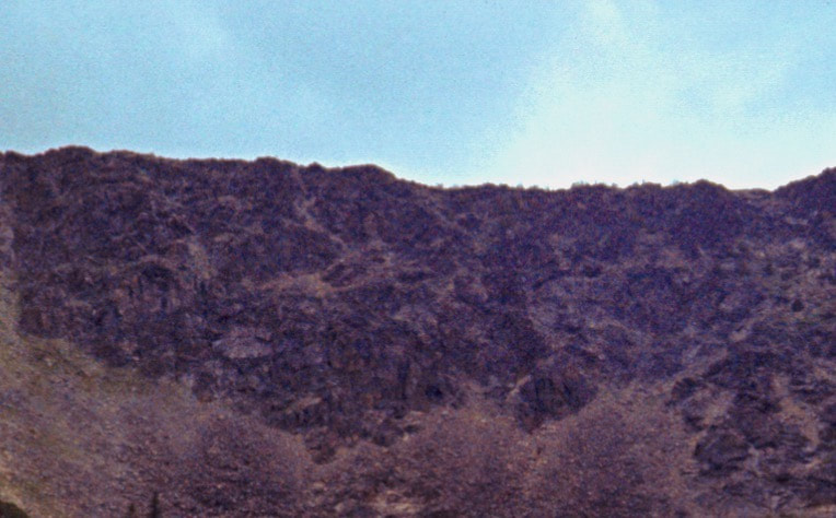
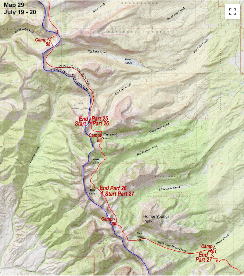
​     July 18 - 19               Anaconda-Pintler Wilderness, MT               (Go to Pt 1)
​
Before we committed to the descent we dropped our packs and pulled out the lunch bag. We didn’t talk much about how we were going descend and after picking through our lunch ration for the day there was really nothing left to do but to start plunge-stepping down the steep scree to the splintered rocks below.
​

The descent was sketchy but turned out to be not quite as steep or as long as coming up the north side had been. We bottomed out at the debris pile collecting at the base of the ridge then traversed back onto level ground.
From here we traveled south along two miles of gentle, rolling tundra, across the upper basin of Moose Creek, then over a gentle rise into the Rock Creek basin.  We traversed the upper Rock Creek basin to the southwest ridge which took us over into the Fourth of July Creek valley.   The ridge was easy to attain and the descent into the upper valley was steep but short.

It was only 4:30 in the afternoon when we arrived at the creek and there was still plenty of daylight left with which to advance our position 
Picture
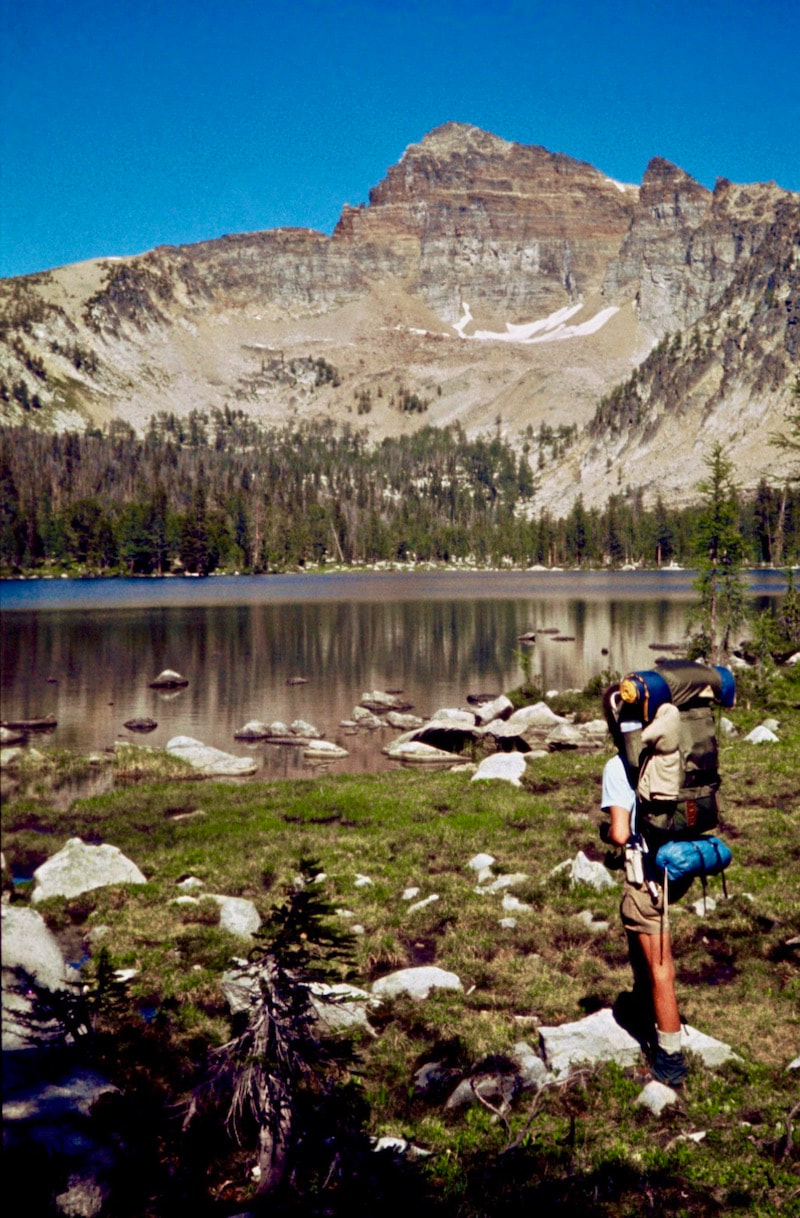
but I just didn’t think my legs could carry me over another pass and Craig kept mentioning his knee joints at the bottom of each excruciating descent.  We were done-in so we set about finding a tent site.

The upper reaches of the valley were narrow and steeply sloped and despite being well practiced at searching out tent platforms it still took a while to find a spot that was not quite big enough nor exactly flat enough for the tent but, with a little ground-clearing and shoring, adequate enough to wedge in a camp.


It rained on and off throughout the night and the next morning everything was wet; the trees dripped all over everything and once we got going the wet underbrush shed cold rainwater all down my bare legs. 

We wasted little time getting out of the brush and back in the sun to the base of a talus slope leading up to the next saddle we needed to cross.  Here we were pleasantly surprised to find a wide, grassy meadow just beyond the talus that made easy work of reaching yet another pass along the Divide.
Picture
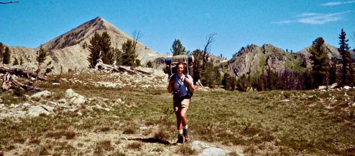
From the saddle we traversed gentle terrain around a cirque formed by the Continental Divide at the head of the Big Lake Creek valley.  We were walking mostly through thin, open forest interspersed with stretches of alpine meadow that reached out across about a mile and a half of gentle geography.  The hiking was far away from any trail and it was absolutely fantastic!  The terrain was a glide and my pack felt like it was carrying half the weight.
Picture
The route eventually led us around to a glittering, sapphire lake, unnamed, just below the ridgeline then up a gentle grade to another saddle.  From there we dropped a short distance into an upper tributary of Big Lake Creek, traversing around the headwaters then dropping slightly in elevation before climbing back up to the Divide.  Here we stopped to consult the maps.

From what I could tell by the map, we were about to cross a long, sprawling pass and then there were two options for getting beyond a long, jagged ridge that intersected difficult terrain along the Divide and blocked our path.
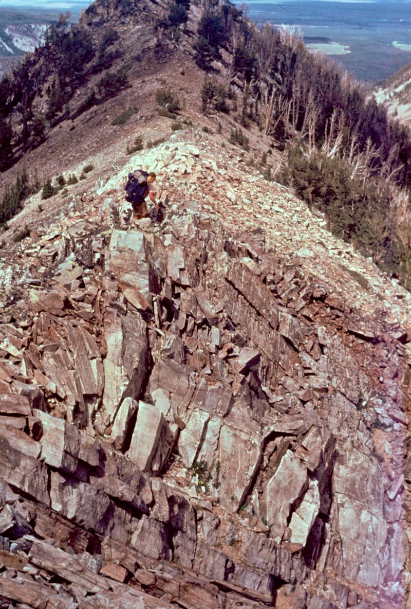
One option was to drop down several hundred feet in elevation and slog our way around the towering peninsula on trails (a plan I did not favor much) or we could commit to a half-mile bushwhack up-valley to climb over a steeply contoured spot on the ridge that we could not yet see. 

I was all for sticking with the route over the ridge but, for the first time since we started the trip in Canada, Craig balked at climbing over a ridge.  He was looking at the steeply stacked contours on the map and shaking his head. 
I was like “What?” It was not like Craig to shy away from a direct route like this.  “Why don’t you want to take the short cut?” I asked.  We were still in the forest and did not have a view of the terrain, so this route planning was purely speculative based on what we saw on the map.  

“What if we get over there and it’s too steep to get up?” Craig asked “It’s a mile out of the way if we don’t get over it.  And look at the backside” he stated, pointing at the steep, south-side contours.   

“Oh common!” came my tactful reply “We cross shit like this all the time!” Craig didn’t respond, he just handed the map back to me and shouldered his pack. 

 “What?” I said, raising my voice. 

“Alright, let’s go” he replied, clearly irritated. 

‘Well, okay’ I thought ‘the saddle it is then’ slinging my pack and marching off into the woods.

We ambled across the long, sprawling pass through open forest until finally we got to where we could get a view of the ridge and our intended route over the saddle.  Well, it did indeed look steep.  
Now I’m thinking ‘oh man, if we get over there and this ridge is not climbable, I’m gonna be eating crow for a week.’  We hiked a ways further through the forest until the trees came to an abrupt halt at the toe of a talus debris pile below the saddle.

At the top of this debris pile there was a grassy ramp that started to weave its way up the slope through the broken rock. I didn’t even pause; I just started up the ramp.  As I got further up I continued to find thin ribbons of grassy ramp carving their way up the slope, through the rock barriers and debris all the way to the top. When I finally got to a point to where I could see we were going to make it over the top of the ridge, I paused to catch my breath. 
Picture
The grassy ramps had made quick work of the climb to the top of the ridge and I was about to give Craig the whole ‘I told you so’ attitude when we walked across the saddle and looked down the other side. ​
Picture
The south side was angled such that all the larger, loose rocks had already fallen to the talus field at the bottom, leaving behind steep gullies of mostly gravel sized scree that was too steep to plunge-step without losing traction and sliding off down the chute.
“Godamit!” I spit.  Craig had dropped his pack and was peering down the mountain face, “Jesus!” he laughed, shaking his head as he turned away.  Having to turn back and descend to take the lower route around this ridge horn was by now unthinkable, at least in my mind.
​ 

There had to be a way to get down the south side of this ridge.  Then I had a most ridiculous idea: what if we did just go ahead and slide down one of the 500 foot chutes on the scree?
Picture

Go to Part 26

Picture
The CDTC was founded in 2012 by volunteers and recreationists hoping to provide a unified voice for the CDT. Working hand-in-hand with the U.S. Forest Service and other federal land management agencies, the CDTC is a non-profit partner supporting stewardship of the CDT. The mission of the CDTC is to complete, promote and protect the Continental Divide National Scenic Trail, a world-class national resource. For more information, please visit continentaldividetrail.org.

0 Comments


Leave a Reply.

    Picture
    Picture
    Kip Rusk, 1977

    Kip Rusk

    In 1977, Kip Rusk walked a route along the Continental Divide from Canada to Mexico. His nine month journey is one of the first, documented traverses of the US Continental Divide. 
    Kip eventually settled in Steamboat Springs, CO where he owned a mountaineering guide service and raised his two daughters.  


    About This Story
    This story is currently being written and will be recounted here for the first time in its original text in a multi-Part format and will continue with a new Part each Sunday until the story ends at the boarder with Mexico. 

    Introduction
         In 1977, I walked a route along the Continental Divide from Canada to Mexico; a trek that lasted nearly 9 months.  My good friend, Craig Dunn, hiked with me as far as the Red Desert in southern Wyoming where his right knee ended the trip for him. This was long before the advent of cell phones, GPS and an established Continental Divide Trail system.  We used U.S. Geological Survey paper maps and communicated with the people who were following us via mailbox and pay phone whenever we came into a town to resupply.   It should also be noted that I’m attempting to recount this story some 40 years after the fact, without the benefit of an exacting memory.  Because of this deficit, the details of my story are filled-in using imaginative memory, meaning, I’ve imagined the details as they probably would have occurred.  This is an account of that adventure.

    Kip Rusk

    Montana
    Part 1 - Glacier Ntl Pk
    Part 2 - May 11
    Part 3 - May 15
    Part 4 - May 19
    ​
    Part 5 - May 21
    Part 6 - May 24
    ​Part 7 - May 26
    ​Part 8 - June 2
    ​Part 9 - June 5
    ​
    Part 10 - June 7
    ​Part 11 - June 8
    ​
    Part 12 - June 11
    Part 13 - June 12
    ​
    Part 14 - June 15 
    Part 15 - June 19
    Part 16 - June 23
    Part 17 - June 25
    Part 18 - June 27
    Part 19 - June 30
    ​Part 20 - July 5-6
    Part 21 - July 7-8
    Part 22 - July 9-10
    Part 23 - July 11-15
    Part 24 - July 17-18
    Part 25 - July 18-19
    Part 26 - July 19
    Part 27 - July 20-21
    Part 28 - July 22-23
    ​Part 29 - July 24-26
    Part 30 - July 26-30
    Part 31 - July 31-Aug 1
    ​
    Part 32 - Aug 1-4
    Part 33 - Aug 4-6 
    Part 34 - Aug 6
    ​Part 35 - Aug 7-9
    ​Part 36 - Aug 9-10
    Part 37 - Aug 10-13
    Wyoming
    Part 38 - Aug 14
    Part 39 - Aug 15-16
    Part 40 - Aug 16-18
    Part 41 - Aug 19-21
    Part 42 - Aug 20-22
    Part 43 - Aug 23-25
    Part 44 - Aug 26-28
    Part 45 - Aug 28-29
    Part 46 - Aug 29-31
    Part 47 - Sept 1-3
    Part 48 - Sept 4-5
    ​Part 49 - Sept 5-6
    Part 50 - Sept 6-7
    Part 51 - Sept 8-10
    Part 52 - Sept 11-13
    Part 53 - Sept 13-16
    Part 54 - Sept 17-19
    Part 55 --Sept 19-21
    Part 56  Sept 21-23
    Part 57 - Sept 23-25
    Part 58 - Sept 26-26
    Colorado
    Part 59 - Sept 26
    Part 60 - Sept 30-Oct 3
    Part 61 - Oct 3
    Part 62 - Oct 4-6
    Part 63 - Oct 6-7
    Part 64 - Oct 8-10
    Part 65 - Oct 10-12
    Part 66 - Oct 11-13
    Part 67 - Oct 13-15
    Part 68 - Oct 15-19
    Part 69 - Oct 21-23
    Part 70 - Oct 23-28
    Part 71 - Oct 27-Nov 3
    Part 72 - Nov 3-5
    Part 73 - Nov 6-8
    Part 74 - Nov 9-17
    Part 75 - Nov 19-20
    Part 76 - Nov 21-26
    Part 77 - Nov 26-30
    ​
    Part 78 - Dec 1-3
    New Mexico
    ​
    Part 79 - Dec 3-7
    Part 80 - Dec 8-11
    Part 81 - Dec 12-14
    Part 82 - Dec 14-22
    Part 83 - Dec 23-28
    Part 84 - Dec 28-31
    Part 85 - Dec 31-Jan2
    Part 86 - Jan 2-6
    Part 87 - Jan 6-12
    ​Part 88 - Jan 12-13
    Part 89 - Jan 13-16
    Part 90 - Jan 16-17
    Part 91 - Jan 17
    ​
    End
© Copyright 2025 Barefoot Publications,  All Rights Reserved
  • Home
  • Hike Rocky Magazine
    • Hike Rocky magazine
    • RMNP Updates
    • Trail Reviews
    • Gear Reviews
    • Science & Ecology
    • History & Current Issues
    • Stories & Adventure
    • Culture and Arts in the Park
    • The Continental Divide Story, 1977 by Kip Rusk
  • Trail Guide to RMNP
    • Trails by Location
    • Trails by Distance
    • Trails by Destination
    • Index of Trails
  • Wildflowers of RMNP
    • April/May Flowers
    • June/July Flowers
    • August/September Flowers
  • About Us
    • Who We Are
    • Supporting Partners
    • Media Kit
    • 2025 Hike Rocky Print Edition
    • 2024 Hike Rocky Print Magazine