The Continental
|
hiking The continental divide, 1977
|
Introduction In 1977, I walked a route along the Continental Divide from Canada to Mexico; a trek that lasted nearly 9 months. My good friend, Craig Dunn, hiked with me as far as the Red Desert in southern Wyoming where his right knee ended the trip for him. This was long before the advent of cell phones, GPS and an established Continental Divide Trail system. We used U.S. Geological Survey paper maps and communicated with the people who were following us via mailbox and pay phone whenever we came into a town to resupply. It should also be noted that I am attempting to recount this story some 40 years after the fact, without the benefit of an exacting memory. Because of this deficit, the details of my story are filled-in using imaginative memory, meaning, I’ve imagined the details as they probably would have occurred. This is an account of that adventure. May 10, 1977 Waterton Lakes National Park, Canada Brian’s Jeep jumped and jolted its way down the muddy track with reckless abandon. The sky was cold and dreary, burdened with moisture-laden clouds spitting a rainy sleet. There was no talk, only Brian’s incessant smirk, which he didn’t even try to hide as he relished the moment. The time had finally come to shut-up and put-up and as far as the ‘shut-up’ part was concerned, naked reality had turned Craig and I into a couple of salt stones. I hung onto the overhead grab by the window as Brian’s maniacal driving plunged us further into the forest until the muddy ruts had turned to slush, coming to an abrupt end at a locked gate. This was the end of the road for Brian but for Craig and me this was the dumping off point. Mile one. Brian hopped out of the truck with unnecessary enthusiasm crowing “This is it ladies… chop chop!” He swung open the back gate of the jeep and hauled out our packs, dropping them in the mud splattered-slush. I stared out the front windshield, willing myself to move. At least the sleet had stopped. Craig stood by the truck, hands in his pockets, surveying the sea of clouds shrouding what little there was to see of the immediate peaks to the south. I stepped out of the vehicle and looked down at my boots, a brand new pair of Galibier Peuterey mountaineering boots designed for “…extreme hiking and climbing”. I wasn’t worried about the boots, they were top of the line, I was worried about the feet in them. I glanced up at the dismal skies then walked slowly around the truck to where Brian was standing by our packs with that damned Cheshire grin on his face. “Need help with your corset?” he sarcastically asked, pointing at my pack.
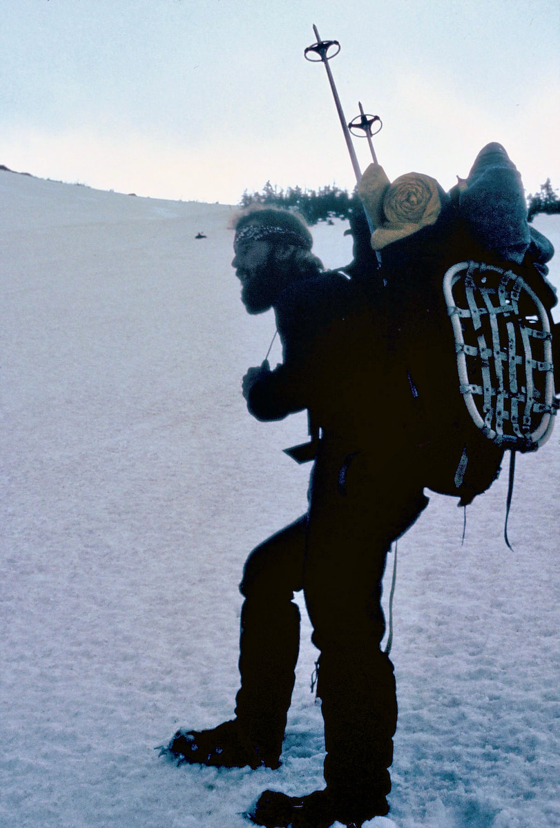
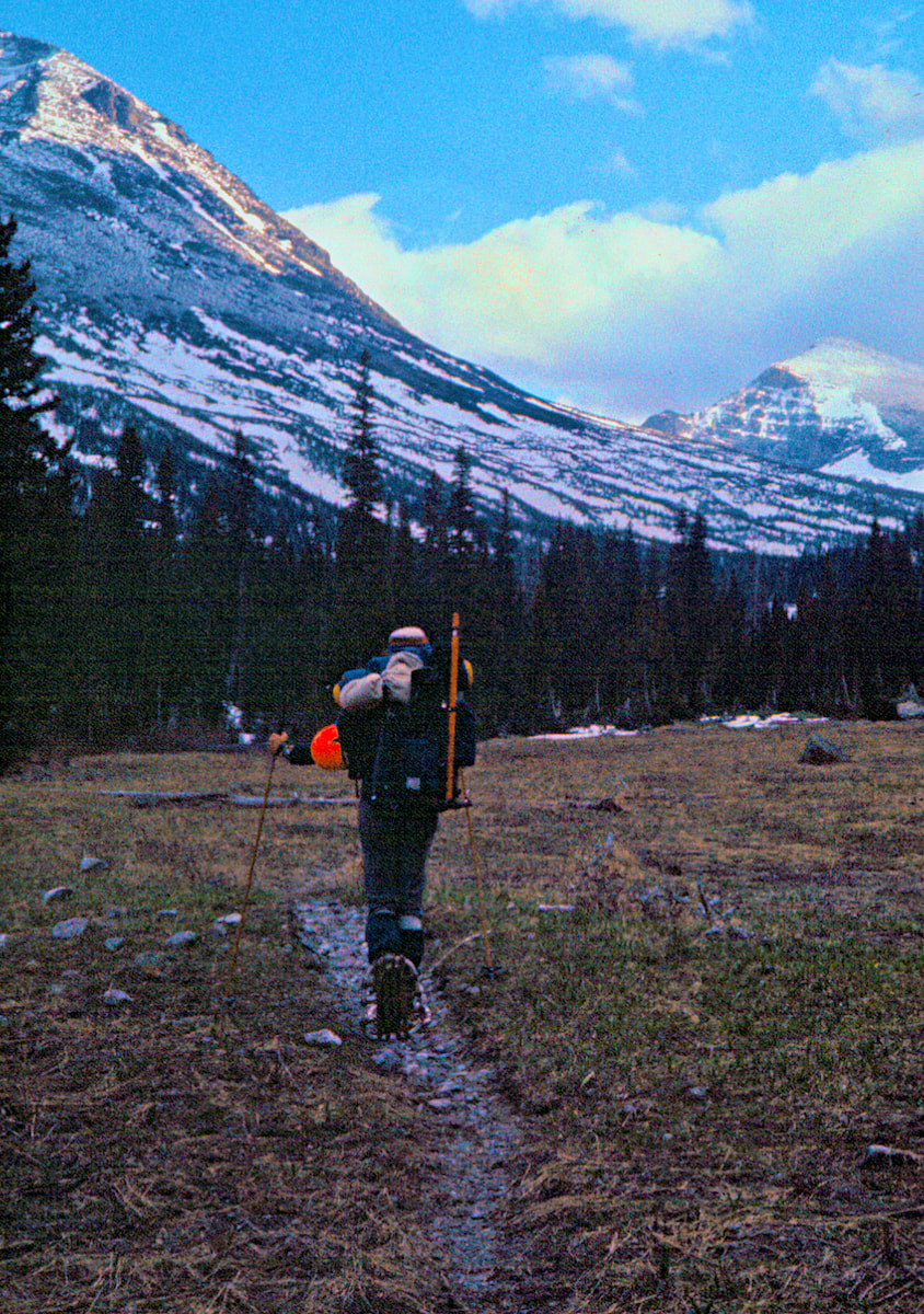
The packs were monstrous, maybe 90 pounds, bulging with 16 days’ worth of food, fuel, winter gear, climbing equipment, snowshoes, repair kit, 1st aid supplies, cook gear, tent, sleeping bags, pads and miscellaneous crap. It was like trying to throw a dead gorilla on your back. “Let me get a picture here so they’ll have something to identify the bodies with later” Brian quipped. He took a picture of us looking heroic at the trailhead then walked up and shook our hands saying “Good luck ladies!” And with that he hopped back in the jeep and was gone. The clouds sagged deeper into the valley reflecting my mood.
webbing and a neoprene strap/binding, an early step away from wooden snowshoes and a precursor to the modern-day shoe. It never occurred to me that they might fail, but it sure as heck ought to have; they were “prototypes” for chrissake. We plodded on along the Cameron Lake trail for several hours before breaking out of the forest onto the huge and exposed east slope of Forum Peak. The open mountainside was steep and an obvious avalanche zone but it was spring and the snowpack had mostly settled and we really didn’t have much choice but to cross it. We picked a line that both traversed the mountain while climbing steeply to attain higher ground out of the trigger zone. However, as we climbed and traversed I could see that we were coming in too low to avoid crossing under a small cirque with a giant cornice hanging overhead.
cornice, we quickly agreed that risking our lives was worth saving the 45 minutes and proceed across the slope. Ten minutes later and only a few yards from safety there was a thundering boom. I swung around and watched in disbelief as the cornice exploded into the cirque and then burst over the rock wall directly above us in a fantastic and terrifying tsunami of ice and snow. My instinct was to turn and run faster than a speeding bullet but I had “bear paws” on my feet and a dead gorilla on my back; I was about as mobile as a turtle in concrete. Still, I lurched forward in the illusion of fleeing as the avalanche crashed into the slope above, roaring down on us with terrifying ferocity. I fell to my knees and screamed out “NOOOOooo” as the wind blast hit and the avalanche passed no more than 10 or 12 strides behind us. Moments later it crashed with another thunderous explosion into Camron Lake, some 1,600 feet below, creating another tsunami of water and ice that traveled across the half frozen lake to slam into the forest on the far bank. Our tracks across the slope had been obliterated. 30 seconds slower and we would have been buried at the bottom of that lake. 30 seconds. 12 strides. It isn’t even worth trying to calculate the number of ways we could have lost 30 seconds and ended up in that avalanche. I staggered up out of the snow and nearly fell over. Craig just sat there, staring down at the lake but there was no time to consider the “what ifs”, the weather was deteriorating into a wind-driven, rain/snow mix and we still had three more, difficult miles before making camp. As we regrouped, all I could think was ‘Really?? Seven hours into the trip and we’re almost dead?’ We weren’t even out of Canada yet, for crying out loud.
0 Comments
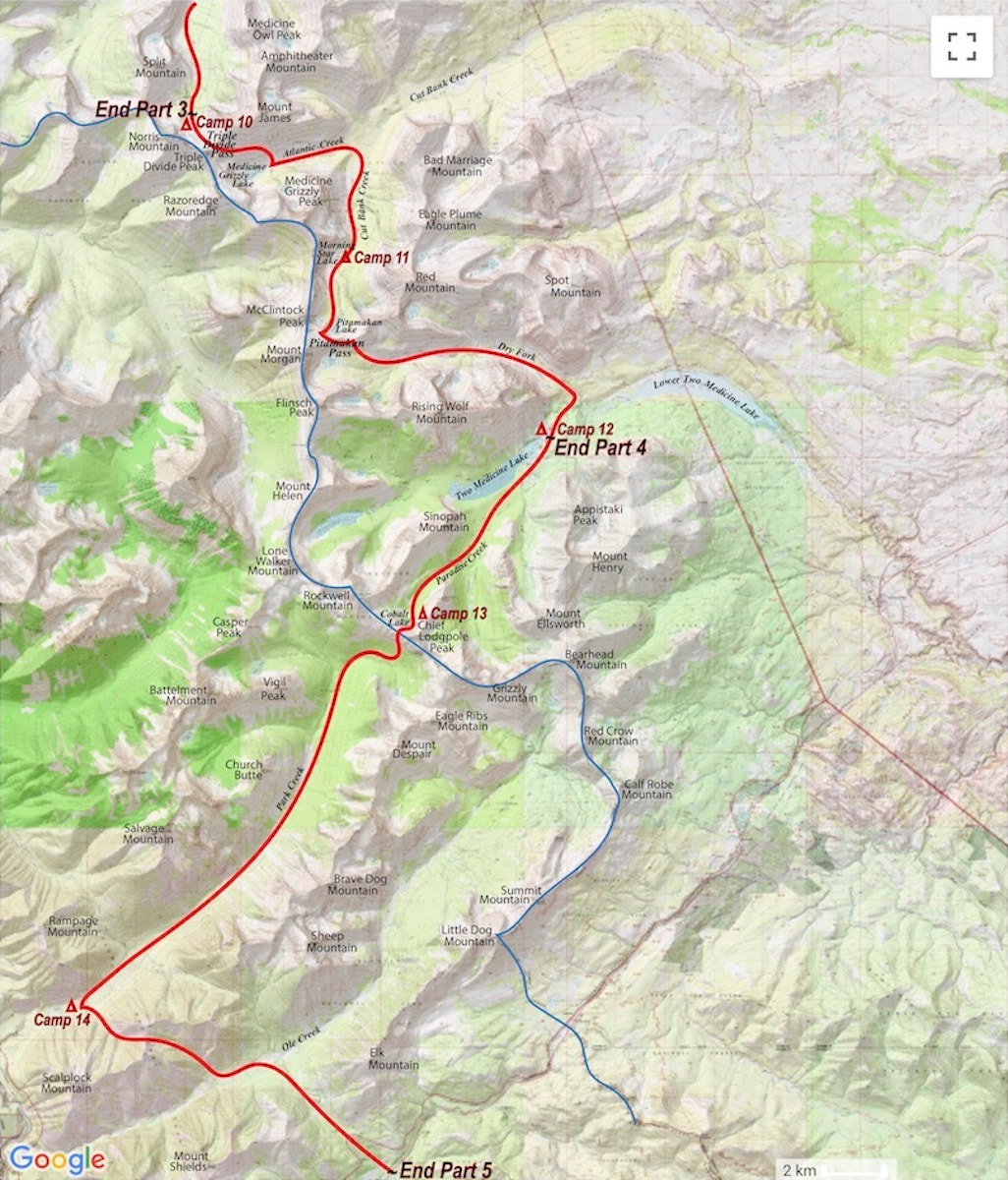
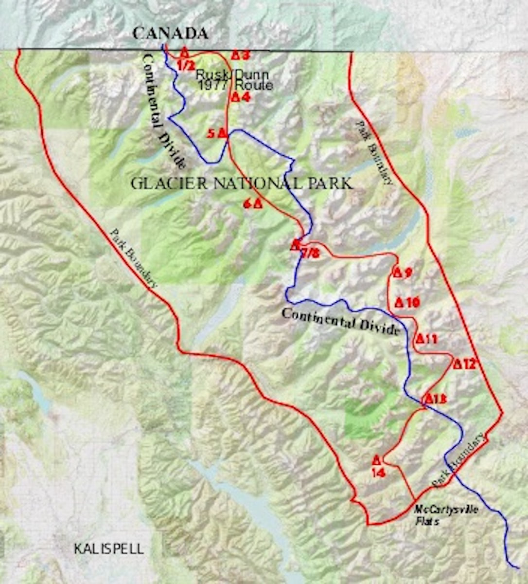
May 11 - May 15 Glacier National Park, MT (Go to Part 1) By the end of our first day on the Divide we had managed to cross the international boundary line into Glacier National Park and make camp in a sopping, wet blizzard near the base of Chapman Peak. Day two we spent tent bound in the same, slop-bucket storm. Throughout the day avalanche gullies released with a muffled boom and surrounding slopes loaded up with an obese layer of ‘Sierra cement’ eager for a trigger. What also became apparent throughout the day was that our whole, overblown idea of traveling “the strictest line” down the Divide was a pipe dream. At least through this stretch it was.
That night the storm cleared out offering up a dazzling and truly ominous view of Chapman Peak and the Continental Divide in the morning. The ridge of the Divide had a massive cornice yawning out over the snow plastered, 4,000 ft. north face of Chapman. One look at that massive avalanche trap and, yeah, there was no way were we going up there. We spent about an hour trying to dry out our damp/wet gear before wrestling everything back into our over-stuffed packs and donning the “snowpaws”. As we plodded off toward the Boundary Trail, tail between our legs, I felt reality shamed. What could have possibly made me think that a couple of beer swilling, pot smoking, redneck hippies from the mid-west could come out here and “conquer” the wild ridge of the Continental Divide through Glacier National Park in May? Probably the beer and weed. But then I thought ‘heck, we’re out, aren’t we?’ I mean, it wasn’t like snowshoeing the entire length of Glacier National Park was going to be some kind of weenie roast.
altimeter out and studied the contours to determine our elevation and how best to angle into the vicinity of the trail. It took a while but we eventually found a few chain sawed logs and finally a trail blaze on one of the trees. Once we found the route of the trail our pace picked up but staying on the trail wasn’t as easy as it may sound. Several times we veered off course because, well, the trail was buried under several feet of snow; it was easy to veer off into the woods and loose the trail but we managed to stay roughly on course. Late in the day, as we approached Waterton Lake, we were faced with a river crossing where the Park Service had removed the temporary bridge (presumably for the winter) and only the cables remained in place. So, at least we got some use out of our climbing gear to rig a traverse across the cables. The next day we set out along Waterton Lake and then up Waterton Valley to camp at a spot near Kootenia Creek. At some point along the way we had managed to lose track of the trail and spent several hours crashing and bashing our way through the deadfall until a fresh set of bear tracks led us back onto the trail and guided us the rest of the way to camp. As we followed the tracks I began to notice how the bear had maintained every little jog and contour of the trail; that’s when the light went on in another “well, duh” moment. Of course, the bears knew exactly where the trails were and from then on, wherever we could find them, bear tracks became our trail guide. It should probably be noted here that Glacier has a healthy bear population, Grizzly’s in particular, and as it was springtime the bears were active and hungry. But I don’t remember being generally concerned about the bears. I mean, we were careful and all; we cooked well away from the tent and strung our food up at night but I always slept well, never worried much about walking around beyond camp and actively hunted for their tracks during the day. Although, I’m sure this was probably owing to the fact that neither one of us had ever been harassed by a bear and were oblivious to the danger. That said, we did not go without our face to bear-face encounters as we traveled. We were sluggish pulling out of camp the following morning, the gorilla sized packs were starting to take a toll and our motivation was waning as we started the long, grueling climb up out of the Waterton Valley toward Kootenia Pass. There was no trail leading up through the Kootenia Valley and no bear tracks to follow but the forest had thinned out such that we were able to amble upwards without the hideous downfall constantly grabbing at our feet. Late in the afternoon we made camp among sparse, stunted trees just below Kootenia pass. The view of the surrounding peaks was stunning, made even more dramatic by the sun setting behind a large storm front bearing down on the ridge. The tent took a pretty good wind lashing in the night, whipping and snapping the nylon incessantly, threatening to rip the tent pegs from the tundra. I could have cared less. I was just too tired to climb out of the tent and check if the danger was real or imagined. If the wind wanted to rip us off the mountainside then hopefully it would be an updraft that would sail us over Kootenia Pass. Somehow, Craig slept through the maelstrom so apparently he cared even less than I did.
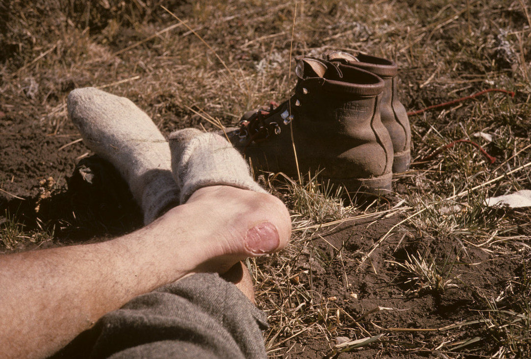
“Hey, Craig” I finally asked “how are these boots working out for you?” “OK I guess; kinda stiff though” he replied. Yeah, stiff enough I was ready to throw mine into the nearest crevasse. We made Kootenia Pass in good time then proceed up the east slope of Flattop Mt. to the plateau on top where we caught sight of a trail blaze. We wandered across the plateau, sometimes on the route of trail but mostly wandering until bear tracks appeared to help guide us the rest of the way along the ridge. Late in the day we descended to Mineral Creek where another bridge must have been hibernating in a Park Service shed leaving only cables across the river. Honestly, I don’t know how we would have made these river crossings without the rope and climbing harnesses, since fording the deep and powerful currents wasn’t survivable. I clipped my harness to the cable, trailed the climbing rope behind me and hand-over-handed the cable to the other side. Craig then clipped my pack to the trailing rope and cable so I could haul it across, then I hauled his pack across with Craig following. At the low point of the cable, in the middle of the river, we had to go horizontal to avoid dragging feet, legs and ass through the drink. Once on the other side my mood soured to find that with all the rocks, downfall and sloping terrain there wasn’t anywhere suitable to set up our tent except in the middle of the trail, which sucked only slightly less than a rocky hillside of splintered wood. I slept like crap with one damn thing or another under the tent floor poking at me all night long no matter what contorted position I tried, which left me tired and cranky in the morning. Craig whipped up oatmeal and hot chocolate for breakfast, the only items on the menu, while I sat gloomily in the tent doctoring up my feet and crabbing about pretty much everything from the “shitty” weather to my “fucking” boots to the color of grass. (Craig’s disposition was about as variable as a desert plateau where as my ups and downs could reach Himalayan proportions.) We broke down camp, gathered our bearings and started a long morning of steep bushwhacking toward Going to the Sun road.
We needed to get to Logan Pass by days end and the road was going to be our route. We plodded off up the pavement a few hundred yards to where a gate had the road closed. On the gate was the obligatory sign warning about bears and another sign that read “Avalanche Danger. No hikers allowed beyond this point.” We ignored both and skirted around the gate. About an hour later a Park Service vehicle rounded the bend up ahead and came to a stop. The Ranger rolled down his window and yelled out “Hey, you the guys hiking the Divide?” We nodded. “Hold tight” he told us. He radioed Park Headquarters and got Bob Fossen, the Park Superintendent, on the other end. “Yeah, Bob, I’ve got the Divide hikers here about 3 miles west of Logan.”
May 15 - May 19 Glacier National Park, MT (Go to Part 1) The Ranger got off the radio and told us “Make yourself comfortable guys, the Park Superintendent is on his way up.” Before starting our trip we had checked in with the Park Superintendent, Bob Fossen, to inform him of our plans and get a permit, which I considered to be a mere formality. But the Park Super had been hesitant to grant us the permit. He had sat at his desk and listened to us matter-of-factly say that we were going to walk the Continental Divide through Glacier; starting tomorrow. After considering this proposal for a moment he got up from his desk and walked over to a map of the park and asked us to describe our intended route.
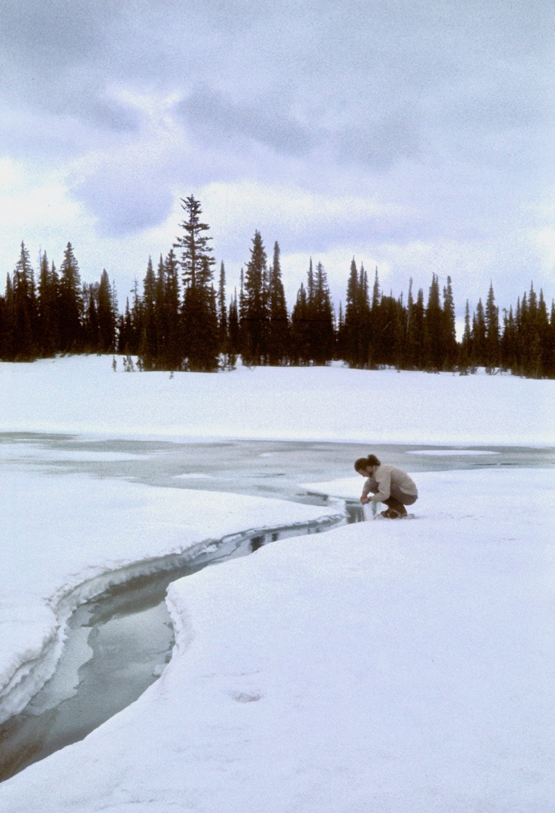
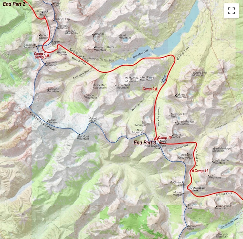
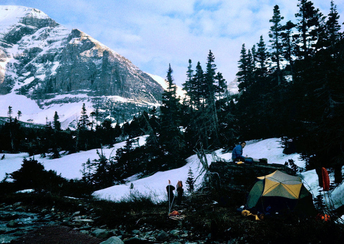
Now he pulled up along the roadside, hopped out of his vehicle and strode over to shake our hands with a look on his face that said ‘I can’t believe you guys are still alive!’ The first thing he did was quiz us about our route then smiled and nodded knowingly when we told him that we had abandoned the ridge. No judgement on his part just relief that we had made a survivable choice. We chatted a bit more and finally he said “Sorry to tell you this boys but I can’t allow you to continue along the road; it’s closed. There’s too much avalanche danger on the Red Garden Wall. But if you want, I can drive you up to Logan Pass.” I looked up the road. We were one hour from making the pass. Then the thought popped into my head that a traditionalist would surely decline this ride and probably go back the way he’d come to find another route. I looked over at Craig and kinda shrugged; he looked back at me like ’So?’ So I turned to the Park Superintendent and said “Gosh Mr. Fossen… that would be great!” Fifteen minutes later we were at the top of Logan Pass. The day was getting on and in the interest of ‘lightening our load’ we decided it would be best if we made camp and drank the beer; so we pitched our tent on a broad ridge near the base of Reynolds Mountain just south of the road. Once we were settled-in with dinner on the stove we popped the suds. The drafts went down like liquid gold and were soon followed by an all-consuming fatigue that began to blot out all else. We were exhausted. Every muscle in my neck, shoulders, back, quads and calves began to rebel at the slightest movement and my feet felt like they were dying a slow and tortuous death. I struggled to the edge of camp to take a leak and in mid-stream realized the only thing that didn’t hurt was my dick. Yet another unstable weather pattern developed in the night and by morning we were engulfed in stormy clouds and wind driven snow. I unzipped a crack in the tent door and peered outside. Visibility was reduced to near blindness with white consuming white. Craig stirred in his sleeping bag and mumbled “What’s the weather?” “Whiteout” I replied. “Can’t see a thing.” He sat up and looked out at the nonexistent terrain “So what’s the plan… Stan?” I shrugged “I don’t know, sleep ‘till noon and reassess?” He slumped back into his bag and replied “Okay, but don’t wake me if it clears.” I did doze on and off until almost noon and finally woke but didn’t stir right away. There was no wind and everything was quiet outside. What I didn’t know was whether we were still engulfed in clouds or if there was enough visibility out there for us to hike. I knew Craig was facing the other tent wall thinking about the same thing. I finally rolled up and zipped open the tent door. The clouds had lifted to about the elevation of our camp and I could see out into the valley below. The visibility was there to navigate. Then Craig looked out and groaned. Our bodies desperately needed some more down time to try and recover from this past week of boot camp but it was clear now that the weather was not going to take full blame for us consuming another day’s worth of food while lying shattered in the tent. We sat at the tent door, still in our bags, and didn’t say a word for the longest time; the scene before us unicorn magical. Just above our camp the dense, dark clouds roiled ever so slowly as if moving in suspended animation. They were illusorily and appeared close enough to touch. Clear views of the valley below would mystically vanish and then re-materialize. The splintered ridge across the valley began to tear away gauzy pieces of cloud that floated almost imperceptibly into the valley. The soft motion of the clouds was calming and mesmerizing. After a while the sky began to brighten but in such a quiet way so as I really didn’t notice it at first. Over time the slate skies had given way to pastels of yellow painted into the higher clouds with lower quilts of mist beginning to glow golden beneath the impending sunlight. Then, just as it was written, the heavens opened up and the sun burst forth in a shaft of dazzling, white light that spilled enormous brightness across the mountainside. We watched the light refract and dance through the clouds and across the forest floor below and then watched as other sunbeams began to appear. Each ray of light displayed a stunningly unique portrait of mountain terrain; all moving with the light. We just sat and watched while the stove melted snow for tea; we weren’t going anywhere. The following morning daylight hit early and with urgency. First light shot straight through the tent and right into my shuddered eyeballs like a starter’s gun going off. We were on the hustle right out of our bags knowing that if we didn’t squeeze every mile out of this day then we’d need a better excuse than cloudy skies to account for it. We were starting to flow into an efficient morning routine; the stove fired with a pan of water heating for oatmeal and drinks while we stuff-sacked everything inside the tent for reassembly into our glutinous packs. Then we ate, crapped, finished packing and prepared for the day ahead. On this particular morning, we started down a deceptively benign looking snowfield which fell gently away from our camp to the upper cliff bands of the Hanging Garden below and quickly discovered we were skating on thin ice. The previous snowfall had left several inches of ball-bearing fresh, buttered over glazed crust making our descent of the precipitous Hanging Garden down to Reynolds Creek both hazardously slick and categorically dodgy. In places we had to heel-kick our way down narrow ramps that led precariously across the top of and around cliff bands. Once I was finally down at the creek, I looked back up at the crags we had just weaved our way through and found it hard to believe that at least one of us hadn’t taken the express off into oblivion. To avoid the extreme and intimidating ridges of Mt’s. Jackson and Logan, our route now had us on another sweeping end run out Reynolds Creek and along the South St. Mary’s Lake Trail. We dropped below the snowline just short of the South Lake Trail and were able to walk off ten miles of welcome trail without the sloppy, Bear Paws snowshoes slapping at the bottom of our boots. We pitched our tent late in the day at the confluence of Read Eagle and Hudson Bay Creeks on a carpet of pine needles beneath clear skies. Sunrise brought another brilliant morning. I lumbered out of the tent and went down to the river to collect water. The air was clean and crisp and fresh with forest aromas. Above, white and rocky peaks stabbed into the cerulean sky and the raucous Red Eagle River flowed full to its banks. Hot Dang! Now this was the way to start a day! In the blink of an eye, walking the Continental Divide went from “what were we thinking?” to “best idea ever!” We ate, crapped, packed up shop and headed out on open trail up the Hudson Bay Creek valley.
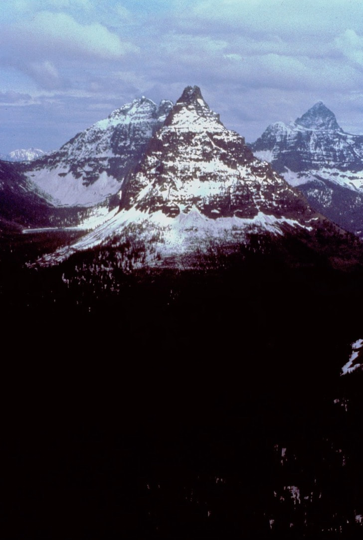
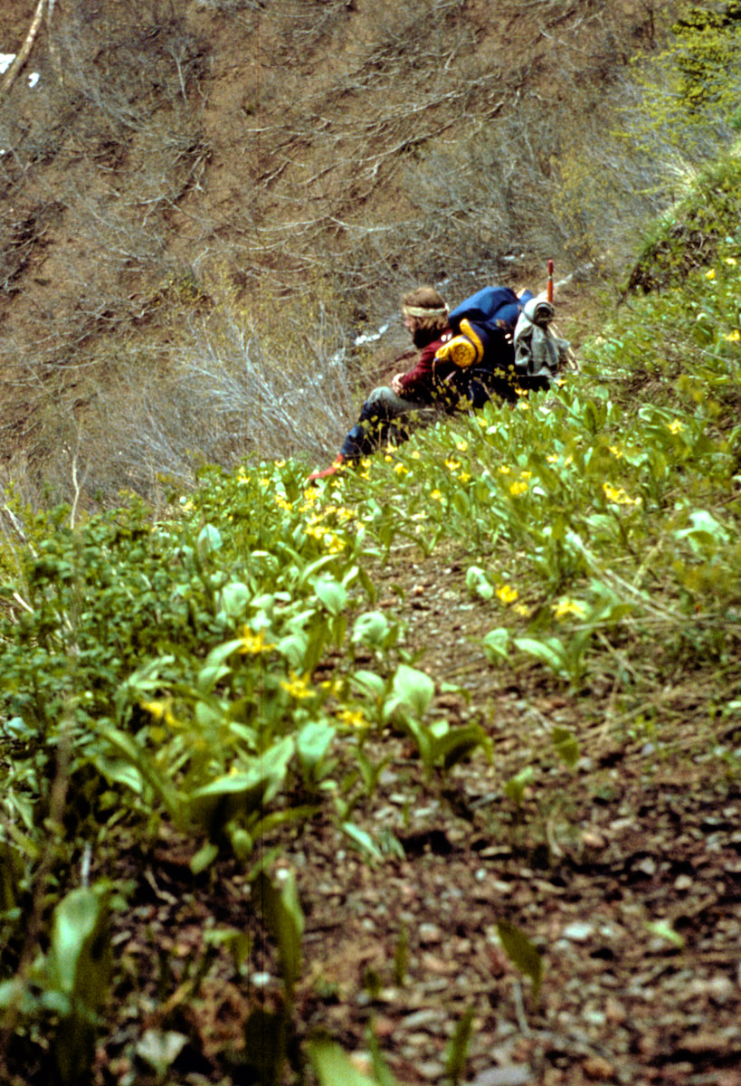
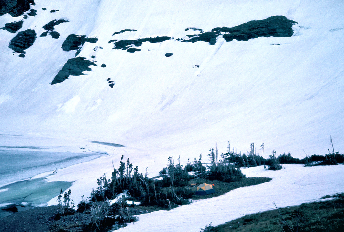
I looked around his pack and saw that he was facing off with a Cinnamon Bear not ten feet away who was looking quite formidable, full-up on his hind legs - because he had been standing up eating berries when Craig and I suddenly appeared from behind the rock. The bear’s face registered shock at this intrusion and everybody just froze. I froze, Craig froze and the Bear froze. Then, instantaneously, the flight instinct kicked-in and while Craig and I tried to levitate our way out, the bear exploded into the brush above the embankment, crashing its way through the thicket and out the other side before we could even find our legs. It took a moment for the adrenaline to track down and I was still shock-eyed when Craig bellowed out “JJJJEEESUS!!” Yeah, no shit! Had that been a Grizzly Bear, Craig could have had the fight of his life on his hands! I probably would have gotten away, thou. Well, we had to keep moving forward but now it was all ‘Lions-and-Tigers-and-Bears’ as we swung a cookpot with a stone in it for a ‘bear bell’ and proceeded gingerly around the corners until we got another mile or so into the upper basin where we had a better view around us. We reached a vantage point where we could survey the terrain and dumped our packs for a look about. We had left the trail under snow a ways back so we made a quick survey of the nearby slopes for bear tracks. Tracks did amble across a snowfield on the far side of the valley but we didn’t detect any warning signs in our vicinity. The massive, north flank of Norris Mountain rose up near vertical to our front and gummed to the face of the rock, about 800 feet up, were a ridiculously nimble herd of Mountain Goats nonchalantly hopping into the abyss from one invisible spot to another feeding on alpine sprouts. We camped that night high in the massive cirque created by the peaks and ridges of Split Mountain, Norris Mountain and Triple Divide Peak. We lingered outside the tent after the dinner food was gone and the shadowed temperatures had fallen into the chill zone. I looked around me and it was an awful lot to try and take in. The fiercely defended peaks surrounding us and the shear difficulty of passing through them; the magnitude of the our endeavor and the mere pittance we had paid thus far; the soul bearing nakedness of our human spirit in such a powerful environment and the discomforting pangs of emptiness the extreme solitude brought. Under twilight the towering peaks took on a dark and monovalent feel, projecting onto me an awareness that death and destruction were also present in the environment. Then, bright little stars began to appear in the sky.
Once the tent was pitched we started unloading our packs, tossing stuff into the tent and, in my case, digging furiously through the sack for my coveted camp booties. Getting those goddam boots off my feet was a luxury all by itself. Once I’d slipped into my camp booties it was important to keep moving because the urge to ‘just sit down for a minute’ was huge, and then one minute would turn
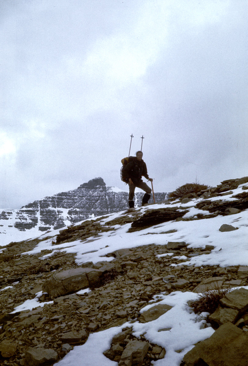
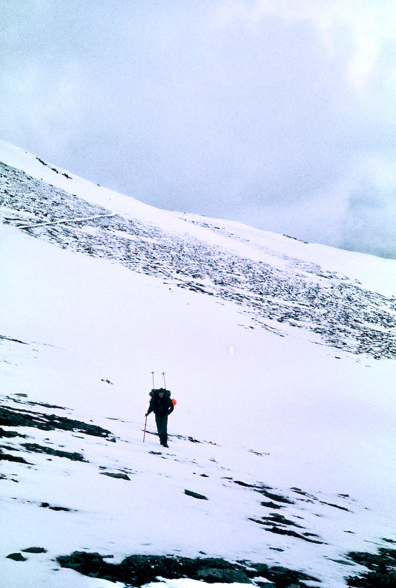
Except this night when my mind refused to shut off. I lay restless and unsettled, listening to the wind howl over the ridge in the distance and come down the valley to incessantly snap at our nylon tent fly. As I lay there, various scenarios of gloom and doom played out in my head: avalanches, bears, crippling falls, river drownings, running out of toilet paper; stuff that would roust me just as I started to doze. Then, when morning finally did come, it was all dismal grey and pissy outside. It was a miserable morning of craping in the freezing-ass rain and packing away damp and wet gear. And then there were those pit-bull boots of mine, now with the added charm of being both cold and wet. I laced up the miserable bastards, strapped on the Bear Paws and loaded on my pack. From our camp we had almost 2,000 feet of elevation gain with several terrain problems to negotiate before reaching Pitamakan Pass. The climb from Morning Star Lake into the upper basin was steep and exceedingly laborious as the snowshoes punched through breakable wind crust at almost every step. It was a brutal go and we swapped out turns breaking trail often, grinding out every foot of elevation gained. Just below the upper basin we came out onto a steep, open slope still holding a potentially unstable wind slab. I didn’t see an obvious route around it without getting blocked out by a cliff band above and, once again, the direct route across the slope begged us to roll the dice. Avalanche safety equipment for us in 1977 included a 100 foot length of red parachute cord, a couple of transceivers, a probe pole and a small shovel. The parachute cord tied around your waist and trailed on the snow behind in the hope that if you did get caught in a slide some of the cord would be visible on the surface of the avalanche debris which would allow a rescuer to pull up the cord and follow it to the victim. The avalanche beacons we had would transmit a signal from a buried victim to what would hopefully not be another buried victim but presumably someone standing close by who could come locate you. Essentially, what we carried amounted to body locating equipment. Anyway, the siren song of the upper valley was calling from just the other side of the slope. We doled out the cord, switched on our beacons and preceded one at a time across the slope; I volunteered to go first. I tried my best to float the crust but punching my boots through was inevitable and the whole thing just grew scarier and scarier the further out across the slope I got. Near the middle I suffered a wave of panic and almost turned back but didn’t and kept going until the boulders were close enough to where I tried to run but pretty much stumbled the last twenty yards to safety. I dropped my pack, sat down on a boulder and looked back across the slope. Now Craig had to cross and there was a pretty good chance that the punched holes I’d made in the slab had left the slope even less stable than before. And I really didn’t want to watch my buddy go down in an avalanche. Craig tentatively ventured out onto the slope and stayed in my boot prints like he was navigating a mine field, not wanting to disrupt any more of what was still holding the thing together. Once he got committed though, he started to move across the slope with more urgency and also ran-stumbled the final yards to the finish. We re-grouped like friends who hadn’t seen each other in a long while and then headed on to the top of the ridge. Turning the crest of the ridge into the high cirque created by McClintock Peak and Mount Morgan was a cold smack in the face. In a matter of a few paces we stepped from a warm, calm day on the lee side of the ridge right into an icy and brutal wind on the other side; the same howling gusts that had blown through our camp in the night. Here, the wind had scoured the basin clear of snow such that the barren, rocky trail now meandered out in front us, skirting Pitamakan Lake to the base of Pitamakan Pass. At the base of the pass we found a large boulder that afforded a measure of protection from the wind and stopped to put on crampons and unstrap the ice axes.
From the south side of the pass, the descent into the Dry Fork Valley looked pretty straight forward and, although there was more snow on this side of the pass, it was also softer, so we elected to forgo the crampons but keep the ice axes handy. As we descended we weren’t paying close enough attention to the nuances of the terrain and unwittingly got drawn into a narrowing gully that offered easy passage at first but then began to steepen. By the time we realized the gully was going to cliff-out below us we were looking at a monstrous climb back up to get out. So we gingerly worked our way down to the cliff’s edge to take a look. I didn’t like the idea of trying to rappel down the cliff band because of how unwieldy the packs would be and especially because there was so much loose rock everywhere. I was hoping we could find another way without relying on the rope. And sure enough, there did appear to be a way to get down through the cliff band but not with the packs on our backs. We took a break while we considered this next option of down climbing about 100 feet of shattered 5th class rock and lowering our packs. Well, we sure as heck weren’t going back up, so we went ahead with the whole circus show of Craig lowering our packs down this loose, junky chimney and me climbing up and down like a yo-yo, freeing the packs from getting stuck. At the toe of the cliff there was a steep snowfield of maybe a hundred yards that fed off at the bottom into a talus slope atop another cliff band. We had coiled and strapped the rope back on Craig’s pack and I had just pick-up my ice axe to start the traverse across the top of the snowfield when both feet suddenly slipped out from underneath me and I began to slide down the slope. The immediate acceleration was alarming as I struggled against the pack to turtle roll off my back and get my axe pick into the snow. I finally got rolled over and made purchase with my axe but the snow was so soft I wasn’t slowing down nearly as quickly as I had hoped. When I finally did come to a stop my feet were resting in the talus rocks at the bottom of the slope. Craig urgently yelled down “Are you OK?” I had started picking myself up out of the snow and yelled back “Yeah, I’m OK”. Then he starts laughing and yells down “what are you doin’ down there?” “I don’t know, practicing my self-arrest, I guess” I mumbled to no one. We descended the rest of the way down to the Dry Fork Valley without further incident and dropped below the snowline out onto the trail. A few miles down the path we spotted a Grizzly Bear ambling along out in front of us; he must not have caught our scent because he didn’t seem to notice we were in the rear. We didn’t follow but stayed still and a minute later something turned his attention down the hill and he ambled off toward the river. We ended up making camp that night at the Prey Lake Campground which came complete with Winnebagos, camper trailers, dogs, kids, slamming bathroom doors, and a Park Ranger. The Ranger came by as we were setting up camp and gave us a ‘congratulations’ on almost finishing our trek through Glacier. Bob Fossen had passed the word on to the Rangers to keep an eye out for the “Divide hikers”. We told the Ranger we’d be out of the park in two more days and he said he’d let our buddy Bob know.
May 21 - 23 Glacier National Park, MT (Go to Pt 1) There was a sense of security being in the campground, just having other people around, and I slept like the dead that night. Next morning we were still dozing in our bags when another Park Ranger stopped by wanting to chat with us about our route through the park. Still in his sleeping bag, Craig pulled a couple of maps from the back of the tent, unfolded them on his lap, and pointed out where we’d been. After the Ranger left we went back to sleep until almost noon with the premature sentiment that Glacier National Park was over when it really wasn’t.
After a few miles, we left Paradise Creek and climbed up into the Cobalt Lake basin where snow conditions were firm and we traveled without needing the ‘Paws’. As we continued into the upper basin, the surrounding peaks’ magnitude became enlarged, soaring up on three sides to create a cirque of steep, fierce terrain that towered above us in graphic relief. I could sense the presence of those towers glowering down on us as we worked our way toward the lake; like we were trespassing through the valley without permission.
Well, apparently two days in a row of good weather was a bit much to hope for because in the morning it was cold with thick, low-lying clouds churning slowly across the mountaintops. The deafening quiet in the cirque made the sound of clanking cook pots at breakfast startlingly intrusive into the hushed surroundings and the cold, menacing skies sparked little enthusiasm for climbing the pass. On this morning we were but infantry with orders to march, so like dutiful soldiers we packed our kits and headed around the lake to the base of Chief Lodgepole Peak.
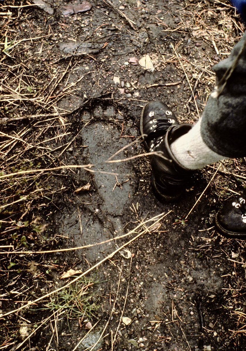
We reached the gully and found it fraught with loose rock. We de-cramponed, then thrashed our way up the scrambled chute while trying not to kill each other by dislodging the precariously scattered debris that lie everywhere. We climbed the last 200 feet on fairly good 4th-class rock, topping out on the ridge to enormous views of Mount Rockwell, Grizzly Mountain, Eagle Ribs Mountain, Casper Peak and the Park Creek Valley Basin. The horizon below the clouds was lost in the distance. You know, some moments are just too difficult to put into words and standing on that ridge with all that profound mountain architecture laid out in front of me is one of those times. There was just so much more out there than ‘scenery’; the raw power to create such fantastically massive configurations to such microscopic precision was beyond my brain’s capacity to fathom. I was in awe. 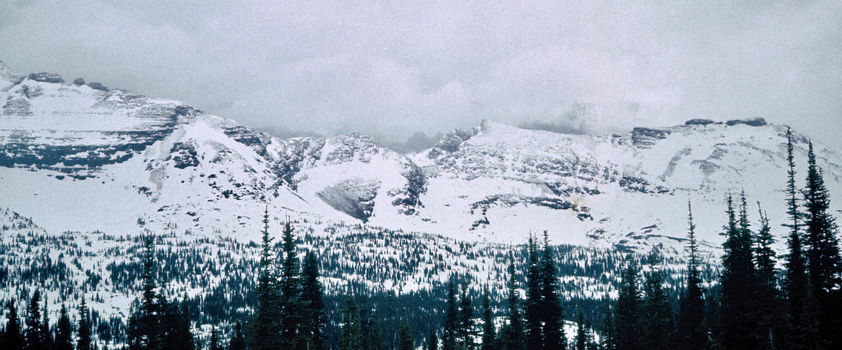 We were now on the Continental Divide’s crest where we continued along the ridge southeast, over Chief Lodgepole Peak, descending to Two Medicine Pass. From the pass we dropped into the Park Creek Valley and were delighted to find very little snow on this aspect of the mountain, making the trail easy to find and follow. We descended quickly to the upper Park Creek Patrol Camp (which had not yet been occupied) then began the long, weary hike out Park Creek. Rain began to fall late in the afternoon making an already muddy trail even muddier. Over the eight miles we’d covered since the pass we had seen all kinds of tracks roaming across and along the trail: Moose, Grizzly Bear, Fox, Elk, Black Bear; enough that when an odd print passed by underfoot I hardly noticed, until the second one caught my eye. Next to my boot was a huge track in the mud that in no way could be mistaken for a bear’s.
We took pictures and peered into the dark, wet forest but saw no signs of movement nor did we hear any cracking or rustling in the underbrush. Okay, well, Bigfoot print, check. We didn’t linger long because we were deadbeat tired and it was getting late; in fact, it was after 6:30 pm when we finally reached the Coal Creek Fire Trail junction where we made camp. And boy, were my dogs barking! That evening it was just plain eerie around camp, like you could almost smell something in the air, and we did hear cracking and rustling in the underbrush, which would not have been unusual given all the wildlife in the area, except we had just seen real Bigfoot prints a few hours earlier. Now there was time to think about it and I started feeling like we were being watched. Then I started to think about all the bear tracks we had seen throughout the day, including Grizzlies, and began to worry about a bear raid. Here we were, ‘Smorgasbord Central’ for a valley of hungry bears, (not to mention the lurking Bigfoot) and especially now that we’d cooked food. Between the Bigfoot and the bears I was definitely starting to tweak, hearing or seeing the Boogie Man out in the dark forest, just beyond camp, every time I turned around. For whatever reason, the tent seemed a safer place to be than sitting outside, so we threw everything but the sleeping bags in our packs and strung them up high from a limb with the climbing rope. Then, figuring Bigfoot and bears must not be able to tree climb, I picked out a tree, close to the tent, in the event I might have to climb myself to safety during the night. And with that, we crawled into the tent and zippered shut the door to our little bubble of pretend security. There was all kind of rumpus going on in the woods throughout the night that kept me restless but nothing that came in and bothered our camp. The next morning was cloudy but not threatening. This was our last day in Glacier National Park but the end wasn’t really all that close. From our camp, the Coal Creek Fire Trail, which was an old and poorly maintained trail, we climbed south and east up 2,000 feet of elevation gain over 2.5 miles to the south shoulder of Soldier Mountain and the whole thing turned out to be choked with downed timber and schmaltzy snowdrifts. We battled our way through it, crossed a shallow, wooded pass and descended through more deadfall and snowdrifts to Ole Creek where we stopped for lunch. Then, as if to pay one more due, we had to de-boot at Ole Creek and ford the swift and icy, knee-deep river while probing blindly with our numb feet across ridiculously slick and sharp rocks. The last mile and a half were up a gentle draw on a game trail that led us out onto State Hwy #2, at McCartysville Flats, around 3:30 in the afternoon. When Brian had left us in Waterton Park 15 days earlier, the plan had been for him to meet up with us right where we were standing now, on this very day, by 5:00 pm. Brian would have been in touch with the Park Superintendent while we were out so he should have had an idea about where we were. I was hoping he’d be parked roadside, waiting for us when we showed up but when that turned out to be wishful thinking I hoped he’d at least show up early. But as the day dragged on toward supper time I started thinking maybe he wasn’t going to show up at all. Around 6:00 pm we finally decided he was a no-show and started hitch-hiking to Kalispell; but then, true to form, the 12th car to come over the rise was Brian’s red jeep, careening down the road.
May 24 – May 25 Kalispell, MT (Go to Pt 1) We spent two nights in Kalispell resupplying our food, fuel, toilet paper, etc. but on this first night in town we went straight to the Roundup Café and chowed down like a couple of hyenas. After the cherry pie a la mode was gone, we stopped by some honky-tonk to have a few beers but didn’t last long before hitting the wall. Sleep, indoors, on a mattress, with a pillow sounded like heaven on earth to me. We got rooms at the motel 6 on the east side of town where I crashed into bed and shattered.
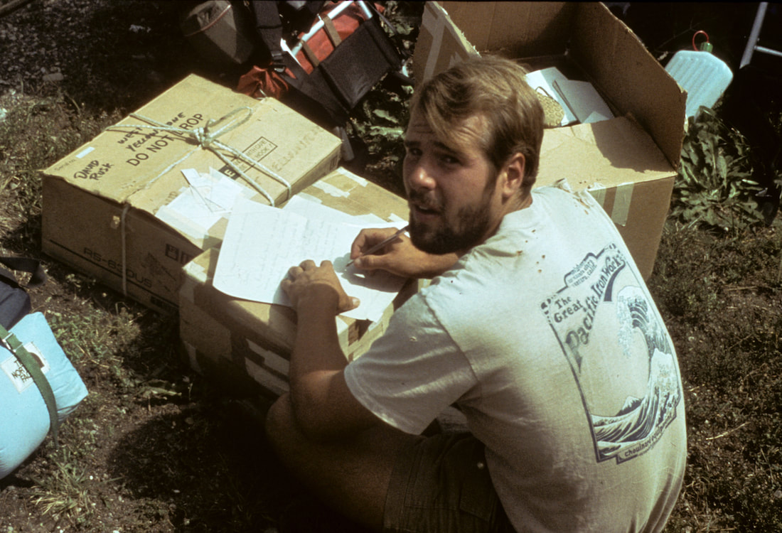
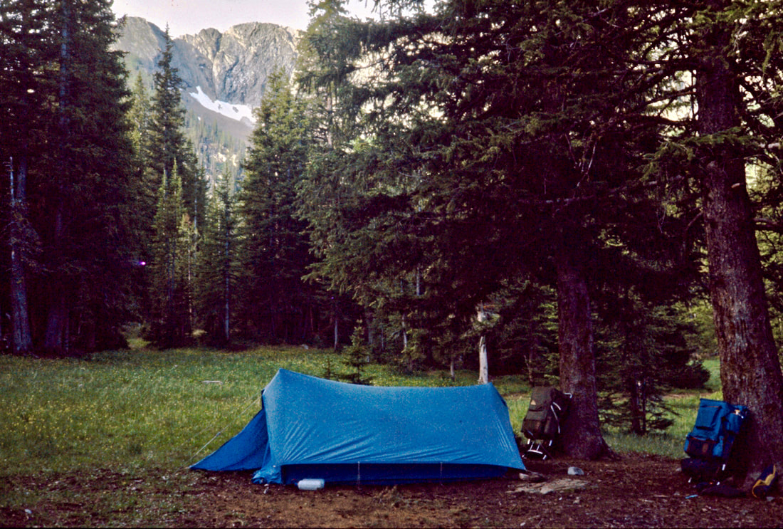
We set about cleaning out the packs and getting all of our damp gear and clothes strung out to dry. The tent needed a good cleaning and airing out so we popped it up in the parking lot to breath. Obviously, being on asphalt, the tent wasn’t staked but didn’t need stakes to stand as it was a brand new North Face Oval Intension - one of the first, successful, free standing dome tents on the market. It had performed admirably through Glacier and I really liked the tent. With the phone calls made and everything laid out to dry and the tent airing in the parking lot, we decided to buzz down to the Shop-n-Hop, just a few blocks away, and get some sandwich stuff for lunch. From what I could tell by looking around the parking lot, we were probably the only ones staying at the motel, so I wasn’t particularly concerned about leaving the tent and being gone for fifteen minutes to get lunch food. We loaded in the Jeep, Brian behind the wheel, who, after pulling out of the parking lot, proceeded to use all of the pavement available, on both sides of the road, piloting us down to the mart. Fifteen minutes later we pulled back into the motel parking lot, bread and baloney in hand, to find our tent gone. “Where’s the tent?” Brian asked. We all scrambled out of the Jeep and ran around to the backside of the building – why the backside of the building I don’t know, there was nothing back there but weeds. Then Craig goes, “The office!” So we all ran back around the building over to the office. I burst through the doors and blurted out, “We had a tent set up over there in the parking lot,” pointing through the window to where the tent had been, “and now it’s gone. Did you see anyone out there take it?” The guy behind the counter paused for a moment and looked at me as if to say ‘idiot tourist’, then asked, “Was it blue and yellow?” “Yeah,” I replied slowly. “Then maybe that’s what I seen blowing across that field out there,” he said, pointing to a desolate stretch of Montana landscape beyond the motel. Damnit! The wind! We hauled back in the Jeep and spent an hour looking in vain for our lost tent. Poof, just like that, our tent was gone. To say we were deflated by this outcome would be to say the Hindenburg deflated on landing. We did have a back-up tent with us but the thought of using it made my disappointment even more acute. In the back of Brian’s Jeep was an old, Gerry Year Round tent that I’d had and knew to be cramped, prone to condensation and, in my mind, questionable with regard to its wet weather, storm resistance. My mood went dark but there were too many other things to deal with for me to brood about it; although, the thought of us losing that spacious dome tent to this cramped, low rent, stake intensive, A-frame shack-of-a-shelter ate at me for weeks. As far as Brian was concerned, the tent problem had been readily solved and it was time for us to get on with resupply and preparations for the Bob Marshall Wilderness Area. Brain had brought with him boxes of dried food: Oatmeal, Cream of Wheat, hot chocolate mix, tea, tang, granola bars, chocolate, soups, rice, potatoes, Mountain House dinner entrées, pudding and dried fruit. To this we would supplement from the grocery store cheese, nuts, sausage, a few cans of tuna, Ziploc bags, TP and more white gas for the stove; three weeks’ worth of provisions would be necessary for this next section. We made a detailed list of everything we needed, gathered up our laundry and headed back into town to visit the laundromat and grocery store.
The next thing to go was the climbing equipment since the mountains ahead wouldn’t require it, then we pared down some of the winter clothing and such but elected to take the Bear Paw snowshoes. The Paws showed some pretty serious signs of wear and material fatigue so I made sure we had plenty of baling wire and duct tape in the kit for repairs. The balance of the day was spent repackaging and organizing the food stock, making sure cook equipment was in order, all loose items back in their assigned stuff sack, resealing seams on rain gear, stitching up torn clothing and snow-sealing the boots. We did our final pack in the morning and after breakfast Brian drove us back out to the Continental Divide. We pulled over at Marias Pass and Brian shut off the engine. The weather was not at all motivating; cold, grey, and snowing with a biting wind. We sat silently in the Jeep and watched the snow blow across the road. From here, Craig and I would start walking south and Brian would start driving east, back to St. Louis. I glanced over at Brian and there was no Cheshire grin, just a look of disenchantment. Over the past year, Brian had made somewhat of a hobby out of following and contributing to our planning process and doing whatever he could to help from the earliest stages of the trip. He had been a third party to all of our raucous bluster and resolute determination to walk the Divide for over a year. But now, having done everything he said he’d do to help us lift-off on the Divide, his role was coming to an end. In a stinging wind, by the edge of the highway we said our ‘good-lucks’ and parted ways. I felt a wave of melancholy as Brian’s jeep pulled back onto the highway and disappeared down the road.
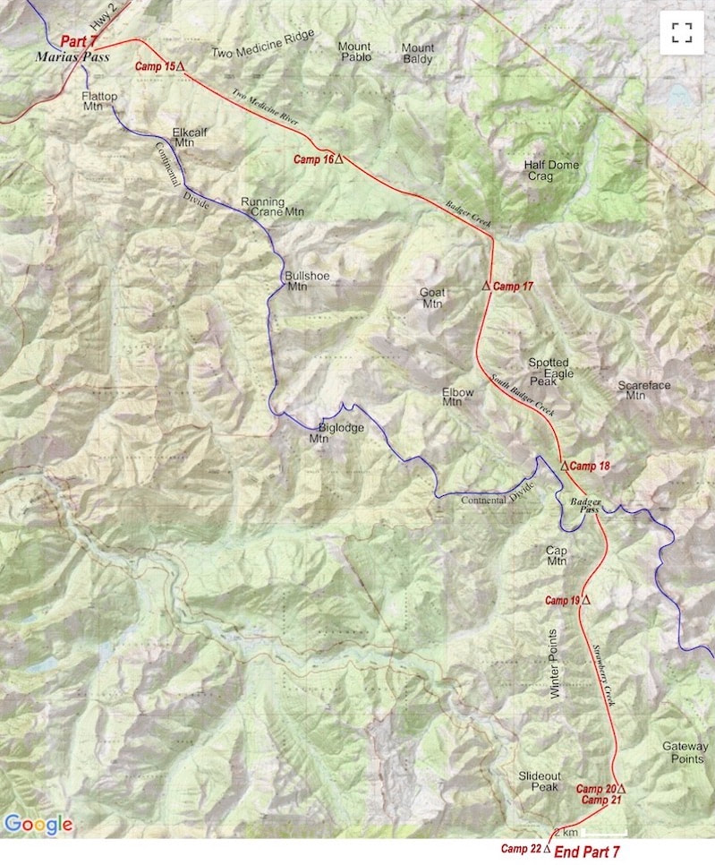
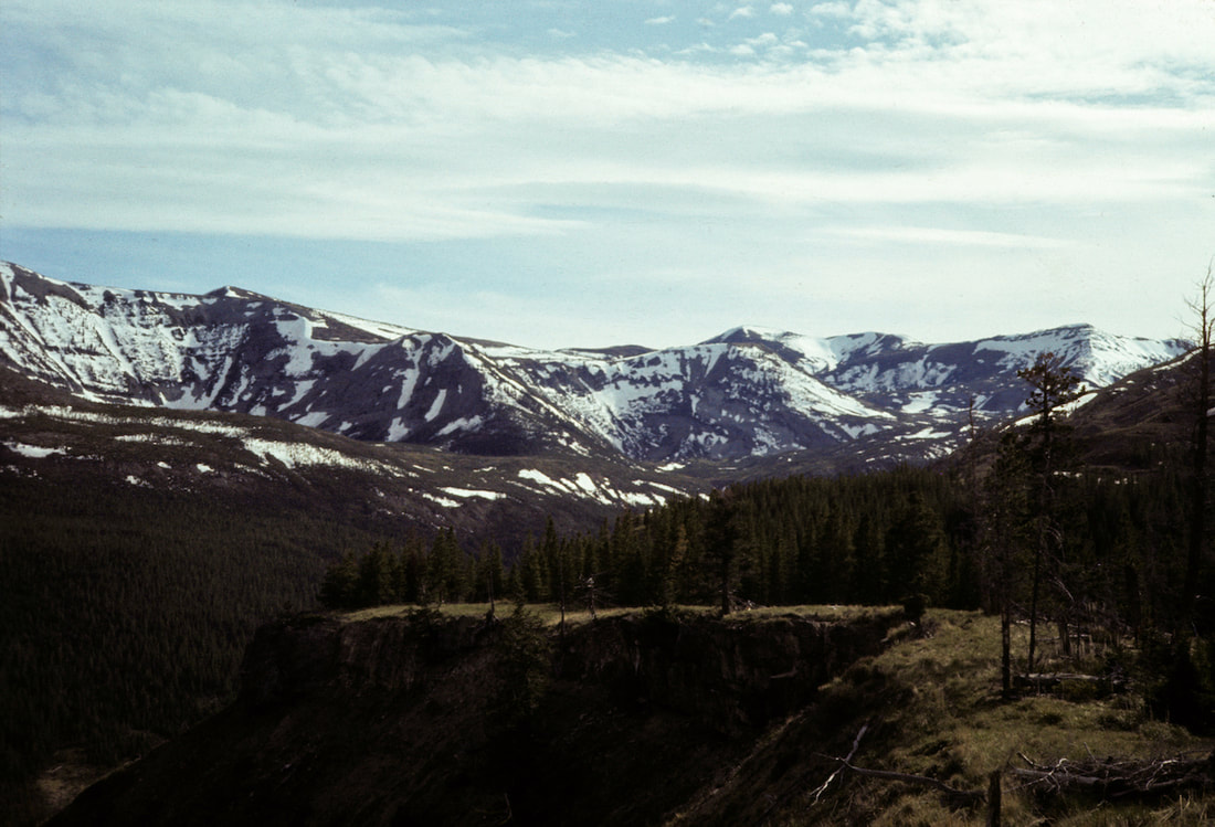
May 26 – June 2 Bob Marshall Wilderness (Go to Pt 1) From Marias Pass we climbed a gentle rise then followed a two rut track into the Two Medicine Creek Valley. Everything seemed disjointed. My mind had been so consumed by getting through Glacier that this sudden continuation into another range of mountains caught me flat on my feet. All of our gear and supplies were prepped, packed and ready to go but my head just wasn’t in to it. And, after being dumped back out into this harsh weather, the search for motivation was proving futile.
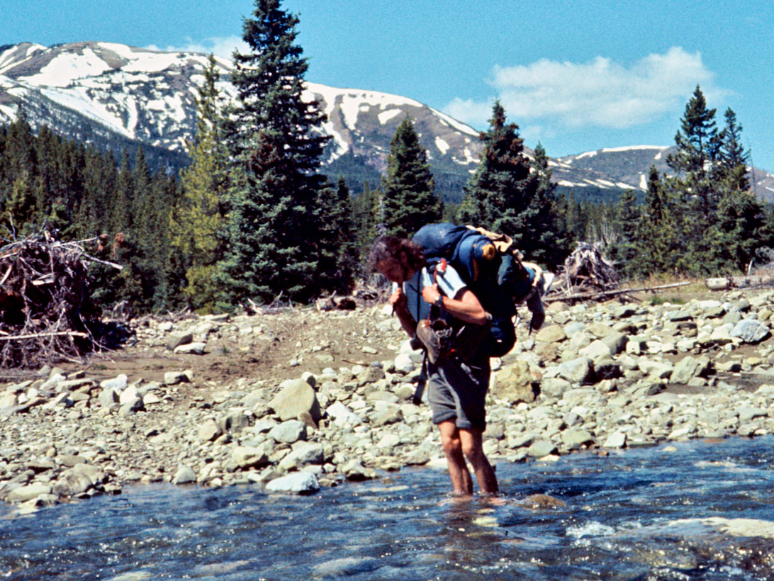
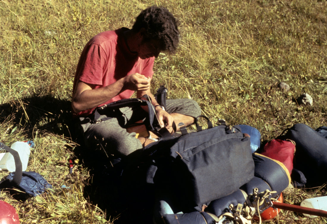
It was impossible to hurry because the rocks were slick, placed haphazardly at all angles, with whitewater making every step blind; then there was that blasted pack, threatening to throw me in the river with every unbalanced move, which was most of the time. When I finally reached the other bank my feet were completely numb from the cold and I had torn skin on all four ankle bones that were surely going to bruise by afternoon. As we were preparing to start off again, I went to buckle the yolk strap to my shoulder straps, the ‘harness’ strap that distributes the pack weight properly across the upper body, and the buckle broke. “Goddamnit!” I spit. Craig looked over and saw the broken buckle in my hand and gave me a downcast look. “Mmm, did you want to fix that right now?” Meaning, ‘You don’t really want to fix that right now, do you?’ “Naw, I fix it later,” I replied. Here we go again, shitty weather, bruised ankles, a load so heavy it should have been on a mule and now a mile after mile fight with my pack straps. All this without pay, mind you, and no tangible reason, whatsoever, to be doing what we were doing, which, at the time, did kind of lead me to ask “Why the fuck are we doing this?” We carried on up the valley and not too long after lunch we got forced out by the terrain into another river crossing. The river sprawled out wide at this point and was relatively shallow with rocks exposed above the rapids. There appeared to be enough dry stones to link up a rock-hop across to a small island in the river, so we left the boots on and proceeded to step, hop and jump from one tippy rock to another out to the island.
almost running stride with no stopping before a fourth boulder offered a landing spot to regroup. From there, one more rock-hop got me to a splashed finish on the far bank. Now Craig was out to the first boulder, steeling himself to make the kangaroo run across to the landing spot. He committed to the sequence of stones but on the last rock, before the safety boulder, I watched in shock as his foot slipped and the pack threw him over into the river. The water was probably only waist deep where he went down but the pack pulled him under and the powerful current started to drag him downstream. As I watched all this instantly unfold, it suddenly occurred to me that I might have to go in after him, so I dropped my pack and started to run downstream through the brush, sticks and rocks. Luckily, Craig had been an outstanding, high school wrestler in his day and in no way was a mere, 90 pound pack going to pin him anywhere. He righted himself back onto his feet in one quick reversal move and then practically launched himself, pack and all, toward the bank. Craig pulled himself up out of the rapids and stood by the edge of the river, absolutely pouring with cardiac-stopping melt-water, and the look of pure shock on his face was total; shock from the near freezing water and the classic look of ‘What the fuck just happened here??’ shock. He dropped his pack in the gravel and water oozed from the seams. Well, this certainly changed our afternoon plans in a hurry. The miserable cold coupled with the wind chill was going to send Craig hypothermic in a hurry. We had to set up the tent and get him out of the wind; the Gerry Year Round tent. This was bad getting worse. We were on river bottom gravels and this damn tent was going to need ten unfailing stakes to stand up properly. Our lost, North Face Oval-intension tent would have popped up in minutes without a single stake; not that that was driving me absolutely mad while I cursed and beat seven marginal stakes into the riverbed pitrun. Craig got in the tent and changed into his long johns while I started lashing all the wet clothes and pack items to tree limbs for drying. We were getting nowhere on this trail; two days in and we were already a day behind.
how apathetic I was feeling and how, after Glacier, I was struggling to get my motivation back to the intensity level required for what we were doing. Craig voiced similar feelings but was more direct in tracing the soured mood back to the blown away tent and how the attitude had gone all gloomy right after that happened. He looked over at me, fairly so. He continued with his train of thought, pointing out that we were here to immerse ourselves in a rugged, mountain adventure so “screw the tent and falling in the river and the shitty weather, we’ve still got a lot of trail to go.” “It’s your turn to wash out the pot” he finally said handing me what was left of the burnt pasta at the bottom of the pan. Sun in the morning certainly helped moral and brought back a revitalized sense of energy. We finally crossed out of the Two Medicine Valley, dropping down to Badger Creek where the rest of the day would be defined by our river crossing tactics. Of seven crossings, we managed to find five, dry passages, using hop-scotch stones to get across, and only twice did we have to de-boot and subject our feet to the ice-dagger torture that the barefoot river crossings were. Toward the end of the day we got suckered off in the wrong direction by an errant trail sign and spent an hour angling up the side of a mountain before finally figuring out the sign had sent us up the wrong fork. Having to backtrack to South Badger Creek was another mistake that cost us both time and energy; we didn’t make our camp until close to sunset, still short of the day’s objective. It took us three days to work our way up through the South Badger Creek Valley, over Badger Pass and down into the Strawberry Creek Valley. The days had turned warm and spring was suddenly in heat. There was plenty of wildlife roaming about the valleys and we saw Black Bear, Moose, Bobcat, Osprey, Bald Eagles, Deer and Elk. For us, the new travel obstacle had become finding our way through the boggy, alpine wetlands that sprawled out across the river valleys and, in their spring run-off conditions, were saturated far beyond their boundaries. Unfortunately, this was also where the majority of the faint to vanishing trail tracked through. We learned right away that wet, soggy boots sucked and following several misadventures of stepping calf deep into liquid-soil that was cunningly disguised by thick moss and tall grasses growing on top, we realized we had to slow down and seek out stretches of ground that would float our weight. All this skirting around and tip-toeing through the boggy wetlands was time consuming and challenged our ability to read the subtle terrain. On the Strawberry Creek side of Badger Pass we found the same marshy wetlands but we also found what should have been a long stretch of good trail already churned up into mud-butter glue by horses, making for miles of slip-sliding trail conditions with globbed-on mud stuck to our boots.
In the near-distance, titanic, thunderhead clouds churned their way up the Strawberry Creek valley, flashing lightning, rolling thunder and pulling with it a dark wall of water that poured into the lower Strawberry Creek valley. We hurried to find a sheltered tent site but all the terrain was exposed, so we staked out the Gerry among the stunted trees, keeping an anxious eye out across the valley to see if the electrified tempest would eventually turn its furry up into the Clack valley.
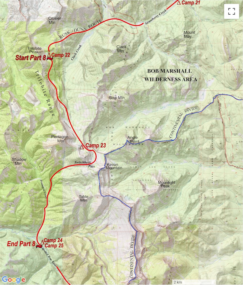
June 2 - 5 Bob Marshall Wilderness (Go to Pt 1) In the near-distance, titanic thunderhead clouds churned their way up the Strawberry Creek valley, flashing lightning, rolling thunder and pulling with it a dark wall of water that poured into the lower Strawberry Creek valley. We hurried to find a sheltered tent site but all the terrain was exposed, so we staked out the Gerry among the stunted trees, keeping an anxious eye out across the valley to see if the electrified tempest would eventually turn its furry up into the Clack valley.
Minutes later a thunderous rain began pounding down on the tent and lightning flashed out to strike Trilobite Peak, instantly followed by ear shattering explosions of thunder that ricocheted off the rock walls and boomed throughout the valley. With every dreaded flash, instant death by lightning strike seemed a real possibility and for ten interminable minutes the lightning detonated all around us with terrifying frequency. The storm’s onslaught lasted for about twenty minutes, then its ferocity lessened and finally petered out. Thankfully, the Gerry tent had shielded us from the torrent of rain pretty darn well. The sky following the thunderstorm cleared and we ventured out to absorb the sweet, pure-clean, alpine air and shimmering views of the glossy-wet peaks and rain-dazzled valleys. Looking about the terrain, there was not much open ground and snow was piled everywhere; it looked like we’d be wading through more schmaltzy snow on the Bear Paws for this upcoming stretch along the Trilobite wall.
I tried to ignore it at first until finally a third strap on my right snowshoe tore off and there was no more putting off the repairs. “I gotta stop and fix this shoe.” I told Craig. He just dropped his pack, sat down and hunched over against the drizzle under his cagoule. It took 45 minutes in the rain to dig out the repair kit, wire bale the straps back together and re-pack. Two hours later it was Craig’s turn with the same problem, same right Paw.  Under the right conditions this stretch along the Trilobite Range would have made for a spectacular piece of hiking but plowing through the mash potato snow under drizzly, misty skies made the entire Trilobite section a slog. Because of the sloggy trail conditions and the multiple stops to repair and re-repair snowshoes, we didn’t get very far over the course of the day and ended up making a wet camp just short of Switchback Pass at a tiny, somber looking pond called Dean Lake under wet, misty skies.
our gorilla loads and made camp in a clearing along the river, savoring the thought of taking the next day off.
 The first highlight of staying parked in camp all day was always the lazy, pancake breakfast with brown sugar and honey. MmMmm!! After feeding our inner-Whine Pooh like men, we gathered the few clothes we had and went to the river to rinse out the grunge and take a bath. After lunch, I took a splendid nap in the sun and that evening, after dinner, we made a warm, cheery campfire where we smoked a drum cigarette and sipped our hot chocolate like seasoned hard-men. Feeling luxuriously rested following our day off, we were ready to grind out as many miles as the day allowed, even though I felt a sense of reluctance to pack up and leave such a serene site. To our advantage, the trail was good right out of camp and held to one side of the river but by late morning the sun had intensified, displaying the flip side of cold and windy with skin-burning penetration and no hope for a breeze. We stopped to douse ourselves in the snow-melt streams every chance we got. Then, near the end of the day, after pounding out twelve, hot, not-exactly-easy miles of elevation gain up the Spotted Bear valley, we arrived at the base of the pass only to find the approach up the long, steep grade, completely slopped out with that damned, heavy, wet, bottomless crap that masqueraded as snow. Climbing the pass under such merciless conditions, this late in the day, was grueling to the point of exasperation but the only way out of this mess was over the top; so it was with a great sigh of reprieve when we found firmer snow conditions on the south side of the pass, which had already been cooled by late day shade cast from an overhead ridge. One, short mile of easy snow plodding got us to our camp, situated by a small, sapphire of water called My Lake.  That evening, Craig and I did a pretty thorough repair /maintenance job on our Bear Paws, knowing that tomorrow’s early sun would make a mash potato mess out of our intended route. We started the next day early, while the snow was still firm, and with no trail to follow we picked what appeared to be the path of least resistance across the south flank of Larch Hill. Turns out we chose a route that offered up a considerable amount of resistance, thrashing us for the better part of an hour with a grueling stretch of vicious timber bashing and bush whacking until we finally managed to dumb-luck our way out onto a melted stretch of trail heading south from the northern toe of the Chinese Wall.
The entirety of the trail along the Chinese Wall was buried beneath lengths and swaths of disintegrating snow that had us on our Bear Paws the entire way, even on open trail, because the change-over from snow to rock back to snow was happening far too often to waste time putting on and taking off the Paws.
ten inches deep in places. As we followed this happy, little mess toward the valley, clouds that had been gathering all afternoon finally decided to rain, no big thunder-banger just a steady rain that settled in.  Then, just before reaching the valley floor, the trail veered right into the raging, South Fork River where it was momentarily erased by twenty yards of thrashing whitewater before emerging on the far bank. And there would be no wading or rock-skipping across this crazed torrent; we were stopped cold at the riverbank.
get up this fat post was with a lot of leg power, squeezing and pushing my way up the log’s back while my arms wrapped around the trunk, desperately hanging on. And shit be gone, it was desperate! The explosive roar of the rapids was deafening and the ferocity of the water below was terrifying and as badly as I wanted to sprint up that log to the other side there was nothing to be done but claw and hump for every inch. Craig followed with the same, pained look of uncertainty that I’d felt right up to that last pull-over onto solid ground. By the time we finally made camp along the Sun River, I was soaking wet, my boots were completely waterlogged and a steady rain continued to fall. We pitched the tent on the driest piece of saturated ground we could find and, bears be damned, we cooked supper in the vestibule of the tent and did not hang our food out in the rain overnight.
|

Kip Rusk, 1977
Kip RuskIn 1977, Kip Rusk walked a route along the Continental Divide from Canada to Mexico. His nine month journey is one of the first, documented traverses of the US Continental Divide. 
Montana Part 1 - Glacier Ntl Pk Part 2 - May 11 Part 3 - May 15 Part 4 - May 19 Part 5 - May 21 Part 6 - May 24 Part 7 - May 26 Part 8 - June 2 Part 9 - June 5 Part 10 - June 7 Part 11 - June 8 Part 12 - June 11 Part 13 - June 12 Part 14 - June 15 Part 15 - June 19 Part 16 - June 23 Part 17 - June 25 Part 18 - June 27 Part 19 - June 30 Part 20 - July 5-6 Part 21 - July 7-8 Part 22 - July 9-10 Part 23 - July 11-15 Part 24 - July 17-18 Part 25 - July 18-19 Part 26 - July 19 Part 27 - July 20-21 Part 28 - July 22-23 Part 29 - July 24-26 Part 30 - July 26-30 Part 31 - July 31-Aug 1 Part 32 - Aug 1-4 Part 33 - Aug 4-6 Part 34 - Aug 6 Part 35 - Aug 7-9 Part 36 - Aug 9-10 Part 37 - Aug 10-13 Wyoming Part 38 - Aug 14 Part 39 - Aug 15-16 Part 40 - Aug 16-18 Part 41 - Aug 19-21 Part 42 - Aug 20-22 Part 43 - Aug 23-25 Part 44 - Aug 26-28 Part 45 - Aug 28-29 Part 46 - Aug 29-31 Part 47 - Sept 1-3 Part 48 - Sept 4-5 Part 49 - Sept 5-6 Part 50 - Sept 6-7 Part 51 - Sept 8-10 Part 52 - Sept 11-13 Part 53 - Sept 13-16 Part 54 - Sept 17-19 Part 55 --Sept 19-21 Part 56 Sept 21-23 Part 57 - Sept 23-25 Part 58 - Sept 26-26 Colorado Part 59 - Sept 26 Part 60 - Sept 30-Oct 3 Part 61 - Oct 3 Part 62 - Oct 4-6 Part 63 - Oct 6-7 Part 64 - Oct 8-10 Part 65 - Oct 10-12 Part 66 - Oct 11-13 Part 67 - Oct 13-15 Part 68 - Oct 15-19 Part 69 - Oct 21-23 Part 70 - Oct 23-28 Part 71 - Oct 27-Nov 3 Part 72 - Nov 3-5 Part 73 - Nov 6-8 Part 74 - Nov 9-17 Part 75 - Nov 19-20 Part 76 - Nov 21-26 Part 77 - Nov 26-30 Part 78 - Dec 1-3 New Mexico Part 79 - Dec 3-7 Part 80 - Dec 8-11 Part 81 - Dec 12-14 Part 82 - Dec 14-22 Part 83 - Dec 23-28 Part 84 - Dec 28-31 Part 85 - Dec 31-Jan2 Part 86 - Jan 2-6 Part 87 - Jan 6-12 Part 88 - Jan 12-13 Part 89 - Jan 13-16 Part 90 - Jan 16-17 Part 91 - Jan 17 End |