The Continental
|
|
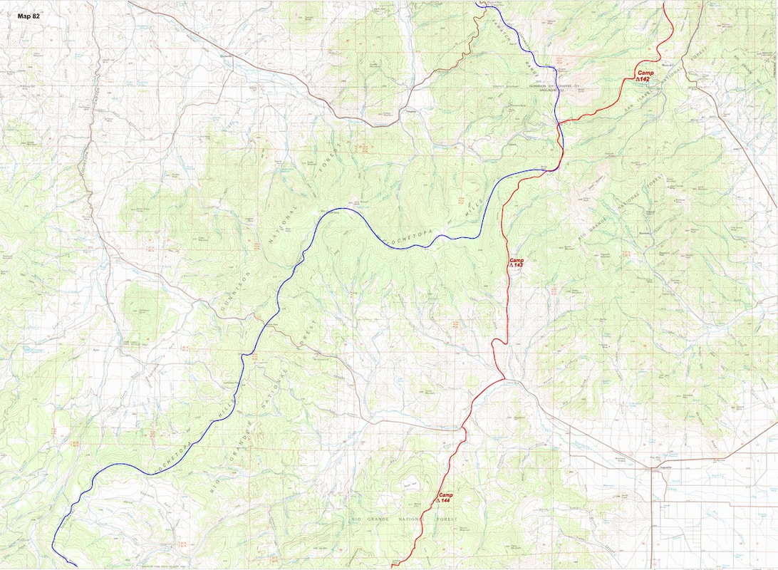
November 21st - 26th Del Norte, CO (Go to Pt 1) The following morning, after breaking down camp, I sat on my pack trying to figure out what to do next. From Indian Creek I would have to rely on a 250,000 series map to navigate my way across the basin and I was really leery about how this map was going to get me back up into the mountains on the other side.
If I were to follow the Continental Divide westward, eventually I would have to cross over the snowbound, La Garita Mountains at almost 13,000ft, and on a trail I would have to find using this 250,000 series map where a gnat’s-ass equaled 1mi. From where I sat, and given the map I had to work with, the only sure bet for getting across the distant mountains was a gravel road straight across the valley from where I sat and which started up from County Road 114 at the bottom of the basin. The map showed this road running up along the extended, Houselog Creek valley, then crossing over the mountains at Carnero Pass which, at just a little over 10,000ft, I figured would still be snow-free, or at least snow-free enough. If I did go that route, though, I would be looking at several, monotonous days on gravel road, and not much about that part of the plan was very appealing, other than it would be easy, but, like I said, it was a sure thing. So with that, I folded up the map and set-off down Middle Creek on a jeep trail that 9, easy miles later, intersected with County Road 114 at the bottom of the basin. An hour of walking south along CR114 brought me to the gravel road I was looking for at Houselog Creek.  From the road junction, I began to work my way back up into the mountains South of the Saguache Basin, setting my camp that afternoon at Browns Creek. Unfortunately, Browns Creek was almost three miles short of where I had hoped to camp, but around mile fifteen in the afternoon I’d started to bonk; I still wasn’t back to full stamina yet from my illness. While unpacking my gear, I checked in with Radio to see if he had anything to report, but there wasn’t much floating around for Radio to hone-in on. I got my supper cooked and after I’d eaten, I laid back in my sleeping bag, eyes closed, and thought about cleaning the cookpot just before drifting off to sleep. Temperatures didn’t even reach the freezing mark overnight and clear, warm, sunny weather continued the following day. At this point, I really didn’t mind being on the road because it was more like a wide trail than a gravel road. There were no vehicles on the road (I hadn’t seen a vehicle since leaving CR114 the previous afternoon) and the battered, rutted thoroughfare wasn’t what you’d call ‘maintained’. The higher up the valley I went the rougher it got.
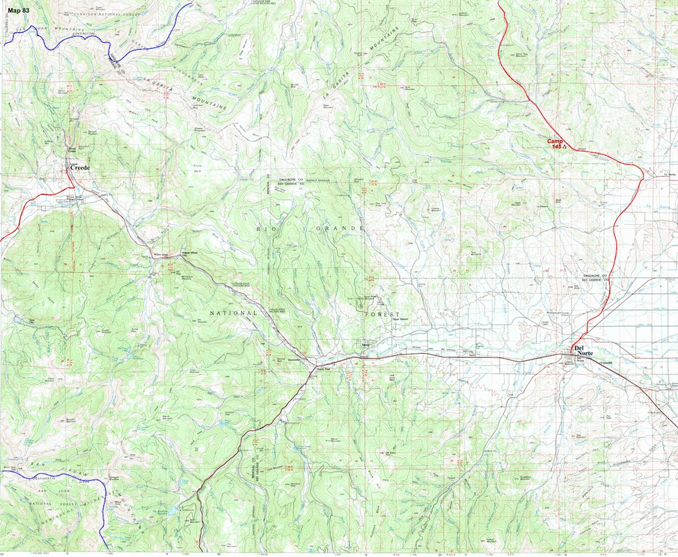
Del Norte was too far for me to reach and anything short of that would potentially leave me trespassing, so I spent the night camped on Forest Service land along Carnero Creek where Radio came back from his hiatus, speaking Spanish. Okay, whatever. We listened to mariachi music while I fixed supper but by the time I was done eating, Radio had, once again, worn out his welcome. It was time to see what the Hobbits were up to. The following day I was only ten or so miles out from Del Norte, so I was able to walk my way into to town by early afternoon. I checked into the El Rancho Motel and, later that evening, around dinner time, my parents and younger brother, Dave, arrived from St. Louis, having driven the better part of two days to come out and join me for Thanksgiving. This plan had come together while I was sick in Salida. As the illness drug on my parents had grown concerned until my Dad started talking about coming out to check-up on me (maybe I was actually poolside in Vegas). Of course, by then I was feeling better so they decided instead to come out and meet me in Del Norte over the Thanksgiving holiday. We spent Thanksgiving together in Del Norte where the North American Falconry Association was holding an annual get together of sorts. On main street, birds of prey of every size, make and model were on display and having dabbled in falconry in high school, I was pleasantly surprised this event was going on and fascinated by the variety of hawks and falcons to be seen up close, even a couple of owls showed-up. On Friday we all drove up the road to Creede and went on a short hike into one of the nearby canyons for a picnic lunch under a warm and brilliantly blue sky. Our time together passed quicky and no sooner had my family arrived than they were packing up to leave, which made for an interesting juxtaposition Saturday morning. As Dad, Mom and Dave packed their suitcases and loaded the car, I was busy re-packaging food supplies and getting my pack reloaded for the next stretch of hiking that awaited me. Once everybody was packed and the car loaded, we all drove up to Creede together and had lunch in a small restaurant before saying our goodbyes. After lunch, my Dad had offered to drive me out to the trailhead, several miles further down the road from Creede, but that would have put them even further in the wrong direction and I’d already come far enough by car as it was; it was just easier to say goodbye to everyone right there in Creede. We hugged and Dad looked pleased while Mom looked worried, and Dave, well, Dave just looked like good ol’ Dave. I watched as my family drove away then shouldered my pack and headed down the road. Go to Part 77
0 Comments
Leave a Reply. |

Kip Rusk, 1977
Kip RuskIn 1977, Kip Rusk walked a route along the Continental Divide from Canada to Mexico. His nine month journey is one of the first, documented traverses of the US Continental Divide. 
Montana Part 1 - Glacier Ntl Pk Part 2 - May 11 Part 3 - May 15 Part 4 - May 19 Part 5 - May 21 Part 6 - May 24 Part 7 - May 26 Part 8 - June 2 Part 9 - June 5 Part 10 - June 7 Part 11 - June 8 Part 12 - June 11 Part 13 - June 12 Part 14 - June 15 Part 15 - June 19 Part 16 - June 23 Part 17 - June 25 Part 18 - June 27 Part 19 - June 30 Part 20 - July 5-6 Part 21 - July 7-8 Part 22 - July 9-10 Part 23 - July 11-15 Part 24 - July 17-18 Part 25 - July 18-19 Part 26 - July 19 Part 27 - July 20-21 Part 28 - July 22-23 Part 29 - July 24-26 Part 30 - July 26-30 Part 31 - July 31-Aug 1 Part 32 - Aug 1-4 Part 33 - Aug 4-6 Part 34 - Aug 6 Part 35 - Aug 7-9 Part 36 - Aug 9-10 Part 37 - Aug 10-13 Wyoming Part 38 - Aug 14 Part 39 - Aug 15-16 Part 40 - Aug 16-18 Part 41 - Aug 19-21 Part 42 - Aug 20-22 Part 43 - Aug 23-25 Part 44 - Aug 26-28 Part 45 - Aug 28-29 Part 46 - Aug 29-31 Part 47 - Sept 1-3 Part 48 - Sept 4-5 Part 49 - Sept 5-6 Part 50 - Sept 6-7 Part 51 - Sept 8-10 Part 52 - Sept 11-13 Part 53 - Sept 13-16 Part 54 - Sept 17-19 Part 55 --Sept 19-21 Part 56 Sept 21-23 Part 57 - Sept 23-25 Part 58 - Sept 26-26 Colorado Part 59 - Sept 26 Part 60 - Sept 30-Oct 3 Part 61 - Oct 3 Part 62 - Oct 4-6 Part 63 - Oct 6-7 Part 64 - Oct 8-10 Part 65 - Oct 10-12 Part 66 - Oct 11-13 Part 67 - Oct 13-15 Part 68 - Oct 15-19 Part 69 - Oct 21-23 Part 70 - Oct 23-28 Part 71 - Oct 27-Nov 3 Part 72 - Nov 3-5 Part 73 - Nov 6-8 Part 74 - Nov 9-17 Part 75 - Nov 19-20 Part 76 - Nov 21-26 Part 77 - Nov 26-30 Part 78 - Dec 1-3 New Mexico Part 79 - Dec 3-7 Part 80 - Dec 8-11 Part 81 - Dec 12-14 Part 82 - Dec 14-22 Part 83 - Dec 23-28 Part 84 - Dec 28-31 Part 85 - Dec 31-Jan2 Part 86 - Jan 2-6 Part 87 - Jan 6-12 Part 88 - Jan 12-13 Part 89 - Jan 13-16 Part 90 - Jan 16-17 Part 91 - Jan 17 End |