The Continental
|
|
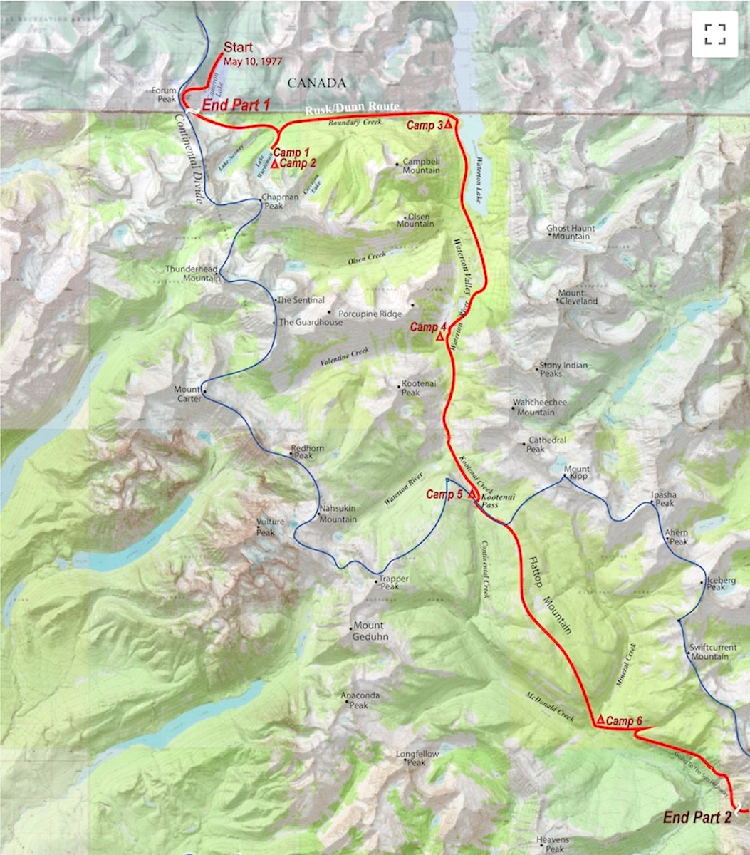
May 11 - May 15 Glacier National Park, MT (Go to Part 1) By the end of our first day on the Divide we had managed to cross the international boundary line into Glacier National Park and make camp in a sopping, wet blizzard near the base of Chapman Peak. Day two we spent tent bound in the same, slop-bucket storm. Throughout the day avalanche gullies released with a muffled boom and surrounding slopes loaded up with an obese layer of ‘Sierra cement’ eager for a trigger. What also became apparent throughout the day was that our whole, overblown idea of traveling “the strictest line” down the Divide was a pipe dream. At least through this stretch it was.
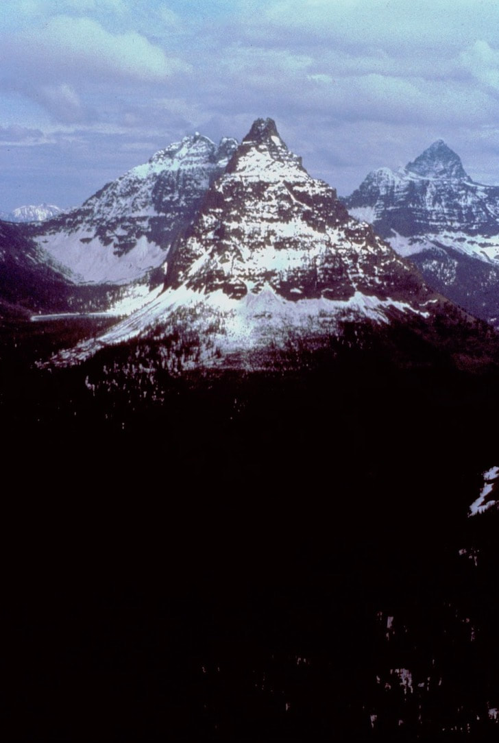
That night the storm cleared out offering up a dazzling and truly ominous view of Chapman Peak and the Continental Divide in the morning. The ridge of the Divide had a massive cornice yawning out over the snow plastered, 4,000 ft. north face of Chapman. One look at that massive avalanche trap and, yeah, there was no way were we going up there. We spent about an hour trying to dry out our damp/wet gear before wrestling everything back into our over-stuffed packs and donning the “snowpaws”. As we plodded off toward the Boundary Trail, tail between our legs, I felt reality shamed. What could have possibly made me think that a couple of beer swilling, pot smoking, redneck hippies from the mid-west could come out here and “conquer” the wild ridge of the Continental Divide through Glacier National Park in May? Probably the beer and weed. But then I thought ‘heck, we’re out, aren’t we?’ I mean, it wasn’t like snowshoeing the entire length of Glacier National Park was going to be some kind of weenie roast.
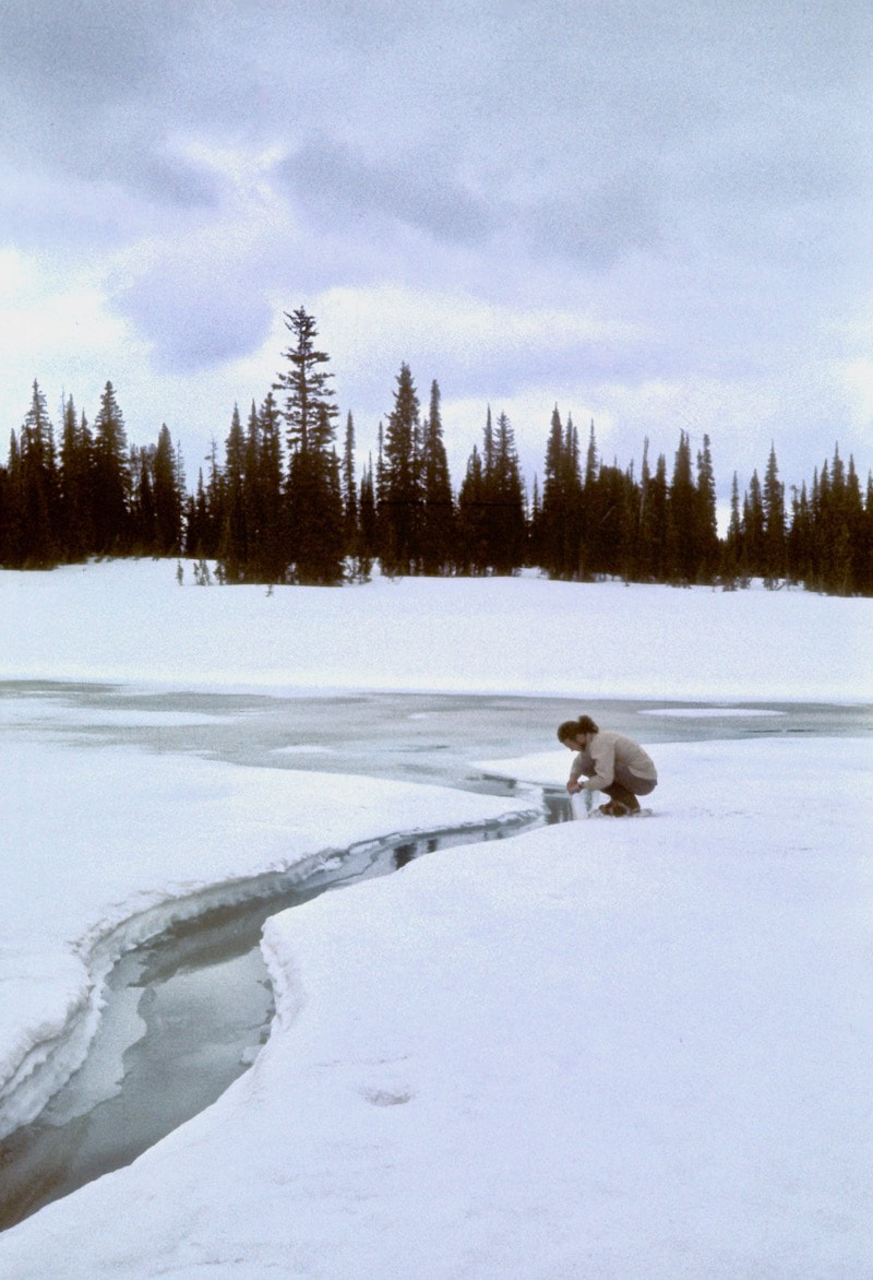
altimeter out and studied the contours to determine our elevation and how best to angle into the vicinity of the trail. It took a while but we eventually found a few chain sawed logs and finally a trail blaze on one of the trees. Once we found the route of the trail our pace picked up but staying on the trail wasn’t as easy as it may sound. Several times we veered off course because, well, the trail was buried under several feet of snow; it was easy to veer off into the woods and loose the trail but we managed to stay roughly on course. Late in the day, as we approached Waterton Lake, we were faced with a river crossing where the Park Service had removed the temporary bridge (presumably for the winter) and only the cables remained in place. So, at least we got some use out of our climbing gear to rig a traverse across the cables. The next day we set out along Waterton Lake and then up Waterton Valley to camp at a spot near Kootenia Creek. At some point along the way we had managed to lose track of the trail and spent several hours crashing and bashing our way through the deadfall until a fresh set of bear tracks led us back onto the trail and guided us the rest of the way to camp. As we followed the tracks I began to notice how the bear had maintained every little jog and contour of the trail; that’s when the light went on in another “well, duh” moment. Of course, the bears knew exactly where the trails were and from then on, wherever we could find them, bear tracks became our trail guide. It should probably be noted here that Glacier has a healthy bear population, Grizzly’s in particular, and as it was springtime the bears were active and hungry. But I don’t remember being generally concerned about the bears. I mean, we were careful and all; we cooked well away from the tent and strung our food up at night but I always slept well, never worried much about walking around beyond camp and actively hunted for their tracks during the day. Although, I’m sure this was probably owing to the fact that neither one of us had ever been harassed by a bear and were oblivious to the danger. That said, we did not go without our face to bear-face encounters as we traveled. We were sluggish pulling out of camp the following morning, the gorilla sized packs were starting to take a toll and our motivation was waning as we started the long, grueling climb up out of the Waterton Valley toward Kootenia Pass. There was no trail leading up through the Kootenia Valley and no bear tracks to follow but the forest had thinned out such that we were able to amble upwards without the hideous downfall constantly grabbing at our feet. Late in the afternoon we made camp among sparse, stunted trees just below Kootenia pass. The view of the surrounding peaks was stunning, made even more dramatic by the sun setting behind a large storm front bearing down on the ridge. The tent took a pretty good wind lashing in the night, whipping and snapping the nylon incessantly, threatening to rip the tent pegs from the tundra. I could have cared less. I was just too tired to climb out of the tent and check if the danger was real or imagined. If the wind wanted to rip us off the mountainside then hopefully it would be an updraft that would sail us over Kootenia Pass. Somehow, Craig slept through the maelstrom so apparently he cared even less than I did.
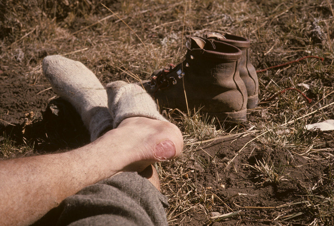
“Hey, Craig” I finally asked “how are these boots working out for you?” “OK I guess; kinda stiff though” he replied. Yeah, stiff enough I was ready to throw mine into the nearest crevasse. We made Kootenia Pass in good time then proceed up the east slope of Flattop Mt. to the plateau on top where we caught sight of a trail blaze. We wandered across the plateau, sometimes on the route of trail but mostly wandering until bear tracks appeared to help guide us the rest of the way along the ridge. Late in the day we descended to Mineral Creek where another bridge must have been hibernating in a Park Service shed leaving only cables across the river. Honestly, I don’t know how we would have made these river crossings without the rope and climbing harnesses, since fording the deep and powerful currents wasn’t survivable. I clipped my harness to the cable, trailed the climbing rope behind me and hand-over-handed the cable to the other side. Craig then clipped my pack to the trailing rope and cable so I could haul it across, then I hauled his pack across with Craig following. At the low point of the cable, in the middle of the river, we had to go horizontal to avoid dragging feet, legs and ass through the drink. Once on the other side my mood soured to find that with all the rocks, downfall and sloping terrain there wasn’t anywhere suitable to set up our tent except in the middle of the trail, which sucked only slightly less than a rocky hillside of splintered wood. I slept like crap with one damn thing or another under the tent floor poking at me all night long no matter what contorted position I tried, which left me tired and cranky in the morning. Craig whipped up oatmeal and hot chocolate for breakfast, the only items on the menu, while I sat gloomily in the tent doctoring up my feet and crabbing about pretty much everything from the “shitty” weather to my “fucking” boots to the color of grass. (Craig’s disposition was about as variable as a desert plateau where as my ups and downs could reach Himalayan proportions.) We broke down camp, gathered our bearings and started a long morning of steep bushwhacking toward Going to the Sun road.
We needed to get to Logan Pass by days end and the road was going to be our route. We plodded off up the pavement a few hundred yards to where a gate had the road closed. On the gate was the obligatory sign warning about bears and another sign that read “Avalanche Danger. No hikers allowed beyond this point.” We ignored both and skirted around the gate. About an hour later a Park Service vehicle rounded the bend up ahead and came to a stop. The Ranger rolled down his window and yelled out “Hey, you the guys hiking the Divide?” We nodded. “Hold tight” he told us. He radioed Park Headquarters and got Bob Fossen, the Park Superintendent, on the other end. “Yeah, Bob, I’ve got the Divide hikers here about 3 miles west of Logan.”
0 Comments
Leave a Reply. |

Kip Rusk, 1977
Kip RuskIn 1977, Kip Rusk walked a route along the Continental Divide from Canada to Mexico. His nine month journey is one of the first, documented traverses of the US Continental Divide. 
Montana Part 1 - Glacier Ntl Pk Part 2 - May 11 Part 3 - May 15 Part 4 - May 19 Part 5 - May 21 Part 6 - May 24 Part 7 - May 26 Part 8 - June 2 Part 9 - June 5 Part 10 - June 7 Part 11 - June 8 Part 12 - June 11 Part 13 - June 12 Part 14 - June 15 Part 15 - June 19 Part 16 - June 23 Part 17 - June 25 Part 18 - June 27 Part 19 - June 30 Part 20 - July 5-6 Part 21 - July 7-8 Part 22 - July 9-10 Part 23 - July 11-15 Part 24 - July 17-18 Part 25 - July 18-19 Part 26 - July 19 Part 27 - July 20-21 Part 28 - July 22-23 Part 29 - July 24-26 Part 30 - July 26-30 Part 31 - July 31-Aug 1 Part 32 - Aug 1-4 Part 33 - Aug 4-6 Part 34 - Aug 6 Part 35 - Aug 7-9 Part 36 - Aug 9-10 Part 37 - Aug 10-13 Wyoming Part 38 - Aug 14 Part 39 - Aug 15-16 Part 40 - Aug 16-18 Part 41 - Aug 19-21 Part 42 - Aug 20-22 Part 43 - Aug 23-25 Part 44 - Aug 26-28 Part 45 - Aug 28-29 Part 46 - Aug 29-31 Part 47 - Sept 1-3 Part 48 - Sept 4-5 Part 49 - Sept 5-6 Part 50 - Sept 6-7 Part 51 - Sept 8-10 Part 52 - Sept 11-13 Part 53 - Sept 13-16 Part 54 - Sept 17-19 Part 55 --Sept 19-21 Part 56 Sept 21-23 Part 57 - Sept 23-25 Part 58 - Sept 26-26 Colorado Part 59 - Sept 26 Part 60 - Sept 30-Oct 3 Part 61 - Oct 3 Part 62 - Oct 4-6 Part 63 - Oct 6-7 Part 64 - Oct 8-10 Part 65 - Oct 10-12 Part 66 - Oct 11-13 Part 67 - Oct 13-15 Part 68 - Oct 15-19 Part 69 - Oct 21-23 Part 70 - Oct 23-28 Part 71 - Oct 27-Nov 3 Part 72 - Nov 3-5 Part 73 - Nov 6-8 Part 74 - Nov 9-17 Part 75 - Nov 19-20 Part 76 - Nov 21-26 Part 77 - Nov 26-30 Part 78 - Dec 1-3 New Mexico Part 79 - Dec 3-7 Part 80 - Dec 8-11 Part 81 - Dec 12-14 Part 82 - Dec 14-22 Part 83 - Dec 23-28 Part 84 - Dec 28-31 Part 85 - Dec 31-Jan2 Part 86 - Jan 2-6 Part 87 - Jan 6-12 Part 88 - Jan 12-13 Part 89 - Jan 13-16 Part 90 - Jan 16-17 Part 91 - Jan 17 End |