The Continental
|
|
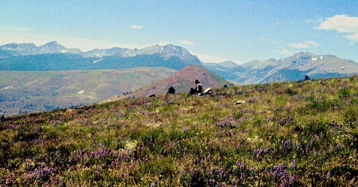
June 27 - June 30 Deerlodge NF, MT (Go to Pt 1) We dropped the packs, pulled off our boots and sat back in the midst of this splendid, botanical display to eat lunch. Craig had been off-pace all morning and wasn’t much interested in eating; saying he was feeling some kind of funk he lounged back against his pack and dozed-off.
I rousted Craig, who started to cause me a little concern with how sluggishly he lumbered back up onto his feet, only to then stand and stare at his pack "Hey, Craig, common man, let's go" I prodded, turning back out along the ridge. Near the base of Sugarloaf Mountain we found a spring of cold, clear water gurgling out of a thicket of Columbine that looked like the perfect place to stop and make camp. Craig was feeling a little better by suppertime and ate most of his ration but was happy to pass on the leftovers. In the morning, Craig felt better but now I was feeling the funk, weak and lethargic as we pulled out of camp.
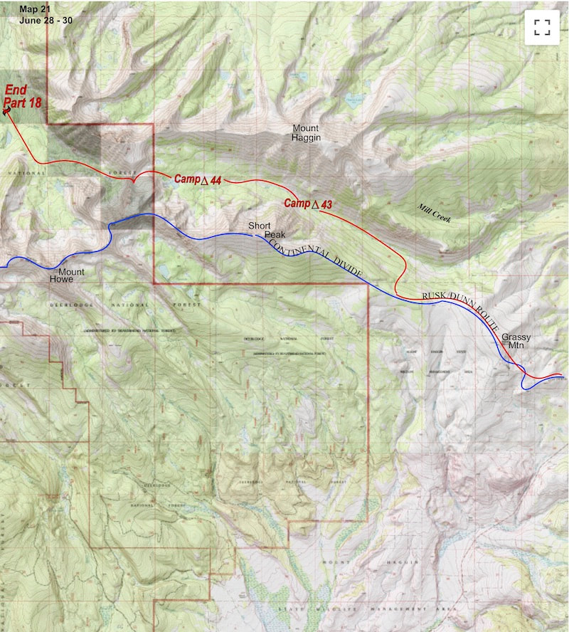
Naturally, we got sucked into a gully that progressively got steeper and the real bugger was that the gully was lined with all this slick, wettish grass that proceeded to take us right to the edge of what was possible to get down without the use of ropes (which we didn’t have, anyways). The mad-gravity made down-stepping a vicious, one-legged, deep-knee bend, leaving the downhill foot little time to plant before gravity would take over. The grade finally got so steep that it was getting hard to simply even stand without slipping and we were spending more time arresting slides down the slick grass than we were navigating on our feet. I felt on the verge of a rag-doll descent the whole way and it was like ‘Shit! Even the damn grass out here wants a piece of me.’ We eventually got down the gully’s final slide but were a little beat-up by the time we made it to Mill Creek, stopping at the river to nurse varying degrees of grass-rash before approaching the next obstacle, crossing the river. The shallowest part of Mill Creek was also the widest part of the river but we pieced together enough rock-hops to get started and, with a few kangaroo jumps mid-stream, we managed to get to the other side dry. We stopped for lunch on a cobbled beach along the riverbank and passed the lunch sack back and forth. I ate but was still feeling washed-out with some pain in my gut and it started me wondering about some of the dank water we had been drinking. After lunch we started up the Mill Creek trail, although to call what we were following a ‘trail’ would be to define the word as 'someplace in the woods' since we were continually climbing over deadfall, studying the pine-needled ground for trail traces and mostly just following our noses through the forest. About an hour after leaving the cobbled beach I really started to feel like crap; lightheaded and weak-kneed with jousting pains flashing around in my gut.
I did not sleep well at all during the night and in the morning I still felt wrecked with little interest in the breakfast granola. Craig was no better off but we packed our stuff anyway and carried on up Mill Creek. Our pace through terrain like this would have normally been around 3mph but as we labored on through the forest our forward progress dwindled to barely a mile and a half per miserable hour. We were both sick, from what we did not know, and by mid-day we just didn’t have the strength to keep pack-muling our way up the valley, calling it quits short of Miller Lake. We ate nothing the rest of the afternoon and only had a cup of soup with rice for dinner. We both slept better that night and felt somewhat recovered in the morning, so we carried on up Mill Creek. It took a long, steep climb to get out of the valley, eventually winding up to the top of a narrow ridge that strung itself between two, towering, unnamed peaks. Our intention was to drop into the Twin Lakes valley on the opposite side of this ridge, so we walked across the narrow crest and took a look down the other side. “Holyshit!” I blurted out right as Craig was exclaiming the exact same thing. Looking down the west side of the ridge was like looking down a church steeple; it wasn’t vertical but it definitely qualified as ‘holyshit’ steep. The wind was ripping over the ridge so we dashed behind a boulder to talk over what our options might be. We pulled the map and studied the various ways to get down off the ridge but found nothing that was going to end us up where we needed to be, except the west side which we had just looked at. We left our packs behind the boulder and went back out to have another look. The mountain was in an active stage of decay and the entire west side was falling apart with loose scree, rocks and talus precariously stacked ata steepness that seemed impossible to hold rocks. Craig and I would have to take different lines of descent, well apart from one another, because we were going to cut loose a lot of rocks descending this face. 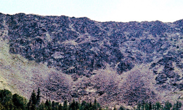 Ridge descent We gathered up our gear and started down. Just to the south of Craig’s line of descent, I keyed-in on a large fin of solid rock rising out from the debris where I hoped to find good handholds. The holds were there and I was thankful to have them the first fifty feet or so as loose rocks shot out from under my feet, careening at ballistic speeds down the face. After several hundred feet, the rock fin that I was using for stabilization ended abruptly and from this point forward it was going to be 500 feet of pulse-pounding descent where every downward movement had to be precisely controlled. The dislodged rocks that bounced and cartwheeled off into oblivion provided a graphic visual of what could happen if either one of us lost it and, to be sure, I wasn’t just freaking out about my ability to control the descent; there were two of us that had to get down this thing unbloodied. We both made it down the rocky, horror show unscathed but rattled to be sure. We took a break in the tundra alongside a splashing stream to regroup and let the adrenaline washout.
0 Comments
Leave a Reply. |

Kip Rusk, 1977
Kip RuskIn 1977, Kip Rusk walked a route along the Continental Divide from Canada to Mexico. His nine month journey is one of the first, documented traverses of the US Continental Divide. 
Montana Part 1 - Glacier Ntl Pk Part 2 - May 11 Part 3 - May 15 Part 4 - May 19 Part 5 - May 21 Part 6 - May 24 Part 7 - May 26 Part 8 - June 2 Part 9 - June 5 Part 10 - June 7 Part 11 - June 8 Part 12 - June 11 Part 13 - June 12 Part 14 - June 15 Part 15 - June 19 Part 16 - June 23 Part 17 - June 25 Part 18 - June 27 Part 19 - June 30 Part 20 - July 5-6 Part 21 - July 7-8 Part 22 - July 9-10 Part 23 - July 11-15 Part 24 - July 17-18 Part 25 - July 18-19 Part 26 - July 19 Part 27 - July 20-21 Part 28 - July 22-23 Part 29 - July 24-26 Part 30 - July 26-30 Part 31 - July 31-Aug 1 Part 32 - Aug 1-4 Part 33 - Aug 4-6 Part 34 - Aug 6 Part 35 - Aug 7-9 Part 36 - Aug 9-10 Part 37 - Aug 10-13 Wyoming Part 38 - Aug 14 Part 39 - Aug 15-16 Part 40 - Aug 16-18 Part 41 - Aug 19-21 Part 42 - Aug 20-22 Part 43 - Aug 23-25 Part 44 - Aug 26-28 Part 45 - Aug 28-29 Part 46 - Aug 29-31 Part 47 - Sept 1-3 Part 48 - Sept 4-5 Part 49 - Sept 5-6 Part 50 - Sept 6-7 Part 51 - Sept 8-10 Part 52 - Sept 11-13 Part 53 - Sept 13-16 Part 54 - Sept 17-19 Part 55 --Sept 19-21 Part 56 Sept 21-23 Part 57 - Sept 23-25 Part 58 - Sept 26-26 Colorado Part 59 - Sept 26 Part 60 - Sept 30-Oct 3 Part 61 - Oct 3 Part 62 - Oct 4-6 Part 63 - Oct 6-7 Part 64 - Oct 8-10 Part 65 - Oct 10-12 Part 66 - Oct 11-13 Part 67 - Oct 13-15 Part 68 - Oct 15-19 Part 69 - Oct 21-23 Part 70 - Oct 23-28 Part 71 - Oct 27-Nov 3 Part 72 - Nov 3-5 Part 73 - Nov 6-8 Part 74 - Nov 9-17 Part 75 - Nov 19-20 Part 76 - Nov 21-26 Part 77 - Nov 26-30 Part 78 - Dec 1-3 New Mexico Part 79 - Dec 3-7 Part 80 - Dec 8-11 Part 81 - Dec 12-14 Part 82 - Dec 14-22 Part 83 - Dec 23-28 Part 84 - Dec 28-31 Part 85 - Dec 31-Jan2 Part 86 - Jan 2-6 Part 87 - Jan 6-12 Part 88 - Jan 12-13 Part 89 - Jan 13-16 Part 90 - Jan 16-17 Part 91 - Jan 17 End |