Rocky Mountain Day Hikes
  • Home
  • Hike Rocky Magazine
    • Hike Rocky magazine
    • RMNP Updates
    • Trail Reviews
    • Gear Reviews
    • Science & Ecology
    • History & Current Issues
    • Stories & Adventure
    • Culture and Arts in the Park
    • The Continental Divide Story, 1977 by Kip Rusk
  • Trail Guide to RMNP
    • Trails by Location
    • Trails by Distance
    • Trails by Destination
    • Index of Trails
  • Wildflowers of RMNP
    • April/May Flowers
    • June/July Flowers
    • August/September Flowers
  • About Us
    • Who We Are
    • Supporting Partners
    • Media Kit
    • 2025 Hike Rocky Print Edition
    • 2024 Hike Rocky Print Magazine

The Continental
Divide Story, 1977
​by Kip Rusk

Part Thirteen

8/11/2019

0 Comments


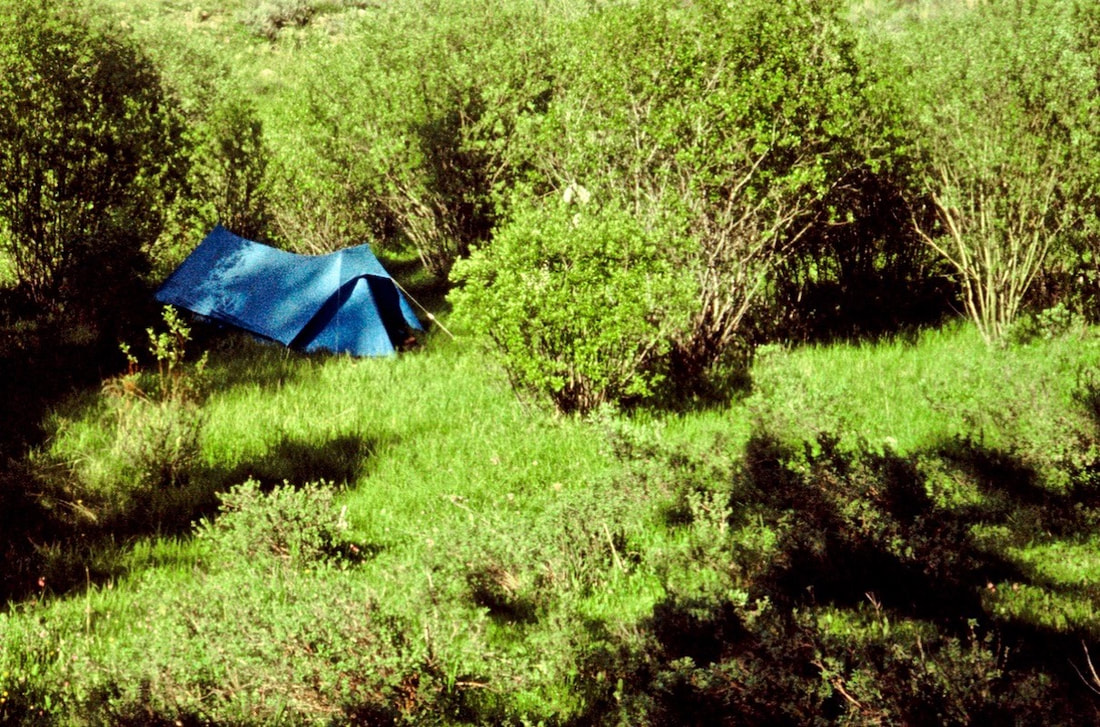
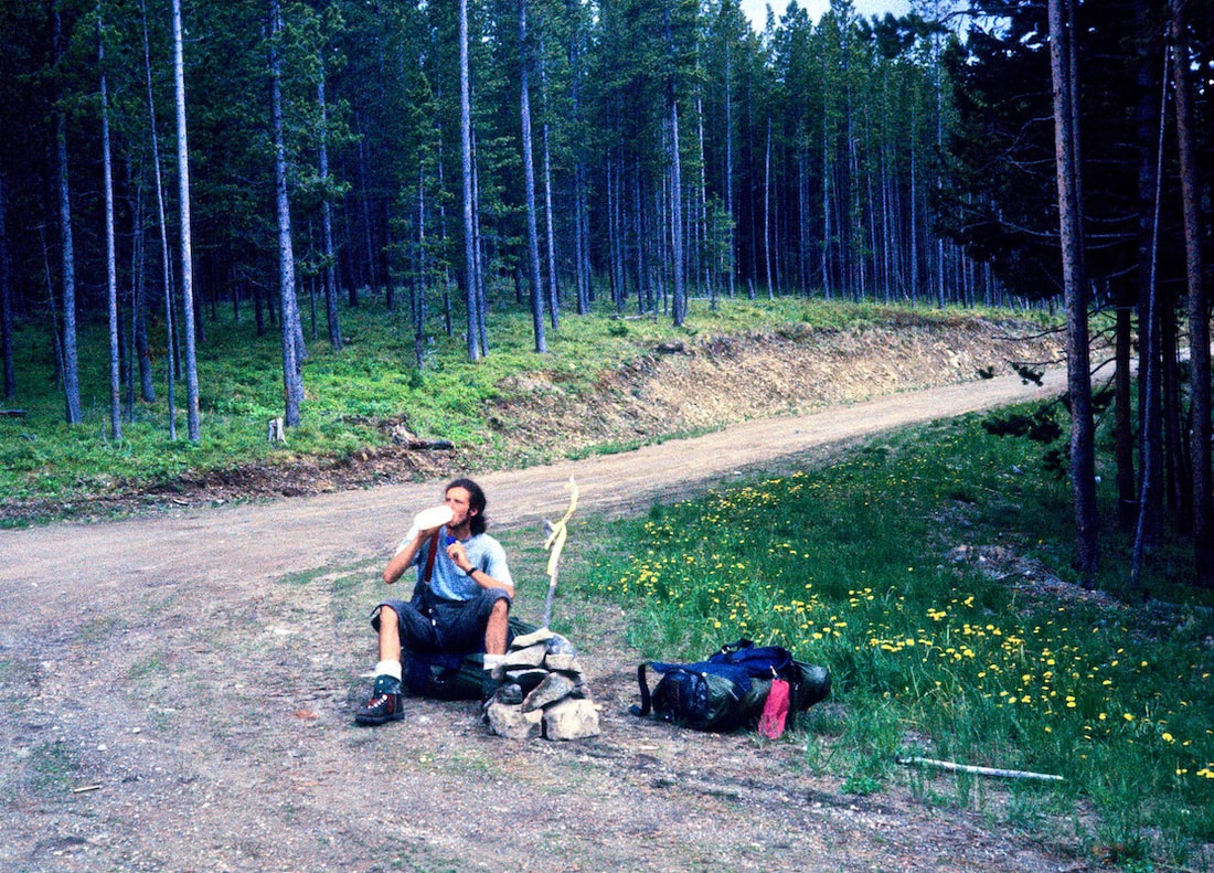
     June 12 - 14             Bob Marshall Wilderness, Montana             (Go to Pt 1)
​

Set at the edge of an open and tidy forest, not 30 yards from the riverbank, was a huge Spruce tree whose lower limbs were a high reach off the ground and fanned out to umbrella a large area of clean, thick pine needles, more than enough room for our tent and a small but spacious front yard for cooking.

We pitched the tent and made a half-assed attempt at cooking dinner but settled for overheated, undercooked, glop because we were just too tired and hungry to wait. I dozed off while eating this crud, that’s how tasty the food was and how ready I was to call it quits on the day.

​The next morning I was so sore and stiff it was all I could do just to get out of the tent and take a leak.  The sun was out and it was another sparkling day, so we sprawled out in our enchanting, little front yard to make the usual, workday oatmeal for breakfast.  After the oatmeal was finished we decided to fix some pancakes because Craig had found extra pancake mix in his food bag and nobody wanted to see that to go to waste.
This was not a scheduled layover day and, being as we were lost and all, you’d think there would’ve been at least a little urgency to get moving; yet, neither one of us had made any effort at all toward packing the bags or breaking down camp.  

​As we languished over our second breakfast, I finally confessed “I don’t think I can go today.”  Craig nodded his head in agreement and conceded “Yeah, I don’t think I can do it today either.”  And with that formality out of the way, I relaxed back against my packrest to enjoy the splendid morning sun and the rest of a very placid day, lost in our happy, little piece of Montana wilderness somewhere along the Landers Fork River.
Picture
Click on Map to enlarge
The glen where we camped was bursting with wildflowers and all along the cobbled riverbank Columbine, vibrant Paintbrush and Wild Iris thrived in dense clusters and Beargrass fuzz intermingled with Fireweed to carpet the open meadow bordering up to the forest.  From riverbank to forest, the Edenesque gardens created a stunning kaleidoscope of color and texture, shimmering as they reflected the sunlight and swaying in the slightest hint of breeze.

The river ran full, not raucously so but coursed with a powerful, low-rumbling current that included the occasional, muffled sound of rocks, rolling along the river bottom.  Sun filtered down through the overhead boughs and sparkled across the water to spotlight flowers and landscape arrangements of every design. 


As I was taking all this in from the ease of my packrest, I started to look at a short, thick stick, lying on the ground at the edge of our camp and began to see the head of a bird, an eagle’s beak, actually, in the way the broken end had splintered apart. So I went over, picked it up, sat back down, pulled out my trusty, twelve-tool Swiss Army knife and started to whittle. 


While Craig was in the thick of reading James Cavell’s ‘Shogun’, I happily whittled away the afternoon, hewing my branch into a bird, and by sundown I had a pretty decent carving which I later sent to my brother, Dave, for his birthday. 


​The next morning dawned just as clear and serene as the previous one had and the desire to just blow-off another day was tempting; camping in such idyllic spots was not just one of the highlights of being on the Divide, it was part and parcel of why we were even out here, which invariably made packing-up slow and leaving an attitude gear-grinder getting back into hiking mode.
Picture
Craig Dunn on the last piece of Landers Fork (click on image to enlarge)
On this particular morning it seemed more difficult than usual to motivate, which, for one thing, I attributed to the fact that we didn’t really know where we were or where our day would end up.  Until we got ourselves back to a place shown on one of the maps we were carrying, we were basically boxed into the only option of heading south.  ​

​As we progressed down valley after lunch, I started to grow uneasy and 
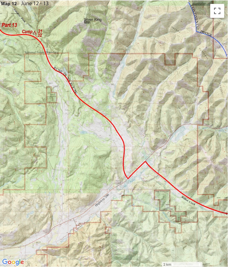
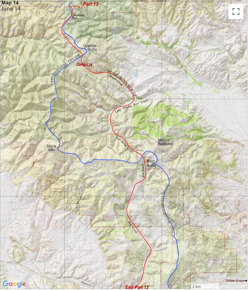
disappointed.  The trail had become a 4W track and then dirt, unimproved road with all the impending signs of civilization.

​The road finally turned to gravel where it emptied out into an expansive, arid valley and by early afternoon we found ourselves standing along the pavement of route 200, considerably west of the Divide.  That much we’d figured out. 
As we stood contemplating our next move, a Forest Service vehicle came ambling down the road, so we waved the guy over to ask where we were.  “About a mile up the road is the junction with 279 and Willow Creek. Willow Creek will take you back up to the Divide” he told us, pointing back over his shoulder.  “How far is that?” I asked.  “Oh, it’s maybe seven or so miles up to Flesher Pass, that’s where you’ll pick-up the Divide” he replied.

​We thanked the Ranger then looked over the maps we were carrying and saw that we did have a map covering the upper Willow Creek/Flesher Pass 
Picture
Click on map to enlarge
area, so this would put us back on route. Unfortunately, this also meant finishing out the day with six, mind-numbing miles of road-warrior walking to reach camp along Willow Creek at the base of Flesher Pass.
Picture
Camp on Willow Creek below Flesher Pass
There was a bit of sporting orienteering on the front end of the day but most of our miles were spent under a hot, washed-out sky on a mining road that made for dull, monotonous hiking.

​We made Stemple Pass late in the day and pushed on another 3 miles into Marsh Creek where we made camp under the umbrella of another, huge pine tree standing out in the open, 
The following day was hot right from the start and we made sure our water bottles were full before leaving Willow Creek because the map didn’t show any, easily accessible water along the route until our next camp near Stemple Pass.  We climbed up to Flesher Pass and then up again, heading south along the Divide.  
Picture
Craig Dunn at Stemple Pass (I don’t know what the rock cairn and yellow flagging is about)
Picture
Click on map to enlarge
chaparral countryside.  For dinner that night we pulled out whatever food was left in our packs, eating what we wanted and leaving the rest for the critters; tomorrow night we planned on chowing in Helena.

​On our last day, the twentieth since Kalispell, we came out onto Highway 12 via Dog Creek and the creek’s name pretty much described our day; we dogged it for mile on top of extra miles, down Marsh Creek, up Lost Horse Creek and out via Dog Creek. We reached the highway late in the afternoon and started the hitch to town; 45 minutes later we were in Helena.

Go to Part 14​

Picture
The CDTC was founded in 2012 by volunteers and recreationists hoping to provide a unified voice for the CDT. Working hand-in-hand with the U.S. Forest Service and other federal land management agencies, the CDTC is a non-profit partner supporting stewardship of the CDT. The mission of the CDTC is to complete, promote and protect the Continental Divide National Scenic Trail, a world-class national resource. For more information, please visit continentaldividetrail.org.

0 Comments


Leave a Reply.

    Picture
    Picture
    Kip Rusk, 1977

    Kip Rusk

    In 1977, Kip Rusk walked a route along the Continental Divide from Canada to Mexico. His nine month journey is one of the first, documented traverses of the US Continental Divide. 
    Kip eventually settled in Steamboat Springs, CO where he owned a mountaineering guide service and raised his two daughters.  


    About This Story
    This story is currently being written and will be recounted here for the first time in its original text in a multi-Part format and will continue with a new Part each Sunday until the story ends at the boarder with Mexico. 

    Introduction
         In 1977, I walked a route along the Continental Divide from Canada to Mexico; a trek that lasted nearly 9 months.  My good friend, Craig Dunn, hiked with me as far as the Red Desert in southern Wyoming where his right knee ended the trip for him. This was long before the advent of cell phones, GPS and an established Continental Divide Trail system.  We used U.S. Geological Survey paper maps and communicated with the people who were following us via mailbox and pay phone whenever we came into a town to resupply.   It should also be noted that I’m attempting to recount this story some 40 years after the fact, without the benefit of an exacting memory.  Because of this deficit, the details of my story are filled-in using imaginative memory, meaning, I’ve imagined the details as they probably would have occurred.  This is an account of that adventure.

    Kip Rusk

    Montana
    Part 1 - Glacier Ntl Pk
    Part 2 - May 11
    Part 3 - May 15
    Part 4 - May 19
    ​
    Part 5 - May 21
    Part 6 - May 24
    ​Part 7 - May 26
    ​Part 8 - June 2
    ​Part 9 - June 5
    ​
    Part 10 - June 7
    ​Part 11 - June 8
    ​
    Part 12 - June 11
    Part 13 - June 12
    ​
    Part 14 - June 15 
    Part 15 - June 19
    Part 16 - June 23
    Part 17 - June 25
    Part 18 - June 27
    Part 19 - June 30
    ​Part 20 - July 5-6
    Part 21 - July 7-8
    Part 22 - July 9-10
    Part 23 - July 11-15
    Part 24 - July 17-18
    Part 25 - July 18-19
    Part 26 - July 19
    Part 27 - July 20-21
    Part 28 - July 22-23
    ​Part 29 - July 24-26
    Part 30 - July 26-30
    Part 31 - July 31-Aug 1
    ​
    Part 32 - Aug 1-4
    Part 33 - Aug 4-6 
    Part 34 - Aug 6
    ​Part 35 - Aug 7-9
    ​Part 36 - Aug 9-10
    Part 37 - Aug 10-13
    Wyoming
    Part 38 - Aug 14
    Part 39 - Aug 15-16
    Part 40 - Aug 16-18
    Part 41 - Aug 19-21
    Part 42 - Aug 20-22
    Part 43 - Aug 23-25
    Part 44 - Aug 26-28
    Part 45 - Aug 28-29
    Part 46 - Aug 29-31
    Part 47 - Sept 1-3
    Part 48 - Sept 4-5
    ​Part 49 - Sept 5-6
    Part 50 - Sept 6-7
    Part 51 - Sept 8-10
    Part 52 - Sept 11-13
    Part 53 - Sept 13-16
    Part 54 - Sept 17-19
    Part 55 --Sept 19-21
    Part 56  Sept 21-23
    Part 57 - Sept 23-25
    Part 58 - Sept 26-26
    Colorado
    Part 59 - Sept 26
    Part 60 - Sept 30-Oct 3
    Part 61 - Oct 3
    Part 62 - Oct 4-6
    Part 63 - Oct 6-7
    Part 64 - Oct 8-10
    Part 65 - Oct 10-12
    Part 66 - Oct 11-13
    Part 67 - Oct 13-15
    Part 68 - Oct 15-19
    Part 69 - Oct 21-23
    Part 70 - Oct 23-28
    Part 71 - Oct 27-Nov 3
    Part 72 - Nov 3-5
    Part 73 - Nov 6-8
    Part 74 - Nov 9-17
    Part 75 - Nov 19-20
    Part 76 - Nov 21-26
    Part 77 - Nov 26-30
    ​
    Part 78 - Dec 1-3
    New Mexico
    ​
    Part 79 - Dec 3-7
    Part 80 - Dec 8-11
    Part 81 - Dec 12-14
    Part 82 - Dec 14-22
    Part 83 - Dec 23-28
    Part 84 - Dec 28-31
    Part 85 - Dec 31-Jan2
    Part 86 - Jan 2-6
    Part 87 - Jan 6-12
    ​Part 88 - Jan 12-13
    Part 89 - Jan 13-16
    Part 90 - Jan 16-17
    Part 91 - Jan 17
    ​
    End
© Copyright 2025 Barefoot Publications,  All Rights Reserved
  • Home
  • Hike Rocky Magazine
    • Hike Rocky magazine
    • RMNP Updates
    • Trail Reviews
    • Gear Reviews
    • Science & Ecology
    • History & Current Issues
    • Stories & Adventure
    • Culture and Arts in the Park
    • The Continental Divide Story, 1977 by Kip Rusk
  • Trail Guide to RMNP
    • Trails by Location
    • Trails by Distance
    • Trails by Destination
    • Index of Trails
  • Wildflowers of RMNP
    • April/May Flowers
    • June/July Flowers
    • August/September Flowers
  • About Us
    • Who We Are
    • Supporting Partners
    • Media Kit
    • 2025 Hike Rocky Print Edition
    • 2024 Hike Rocky Print Magazine