Hike Rocky Magazine articles
|
Rocky Mountain National Park is remarkable, in part, because of the rapid rise in elevation. If a raven were to lift off from the top branch of a ponderosa pine at the Beaver Meadows Visitor Center and fly a straight line to the top of Flattop Mtn, that raven would have flown 8 miles and gained 4,524ft (if another raven also took flight from a nearby ponderosa and headed south for 8 miles, that raven would have to gain 6,459ft in order to land on top of Longs Peak). Over that short 8 miles, these two ravens would have flown over extremely varied terrain and vegetation, classified as the montane, the subalpine, and the alpine life zones. It is a quick lesson on the significance that elevation plays for life on this planet. During the winter, that elevation change plays out in snowfall amounts. On any given winter day, it would be possible to leave the beaver meadows area on a somewhat mild day with patches of snow caught in bushes and hiding in the shadows, and drive up the Bear Lake corridor into full on winter with many feet of snow. Thus becomes the dilemma for the traveler on foot. What foot gear do you use, because many trails can begin with not much snow, where micro spikes are good for ice patches on the frozen dirt trail, but farther up the trail there’s deep snow where skis or snowshoes are the thing to have on your feet. If you want to start on snow, there are basically three main ski corridors in the Bear Lake area. There’s the trial that goes up the Glacier Gorge and leads to MIlls Lake and the Loch, the short trail to Dream and Emerald Lakes that the photographers like to run up in the early morning hours to catch the gorgeous sunrises off of Hallet Pk, and the longer trail toward Flattop Mtn, Bierstadt Lake, and Lake Helene located below Notchtop Mtn. Generally speaking, if you are breaking trail after a fresh snow it can be pretty easy to know where the trail goes through the trees. However, there is one spot on the way to Lake Helene where trail location can be difficult. I followed some tracks that had lost the trail on my way over to Lake Helene. Quite a meander. I finally gave up and navigated my own way. 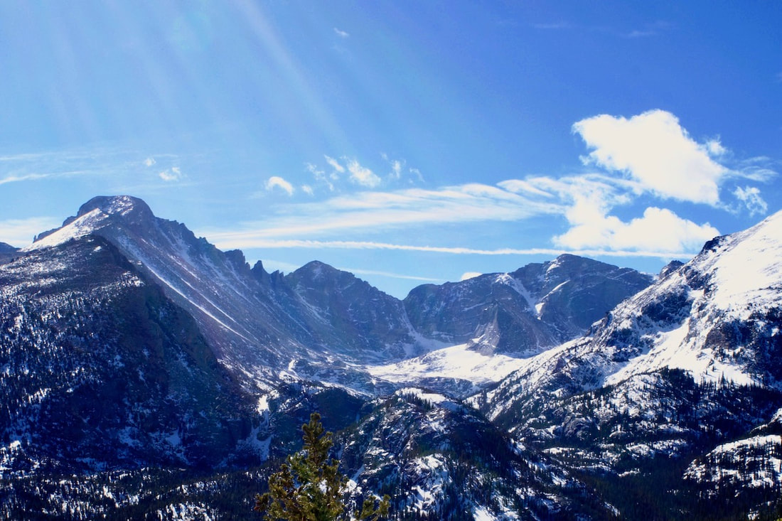 Looking into the upper Glacier Gorge from the Flattop Mtn trail Looking into the upper Glacier Gorge from the Flattop Mtn trail I began at the at Bear Lake parking lot at a lazy 10:00. The day was clear, warmish, and mostly calm with some breeze, and for most of the day I traveled without my hat and gloves on and my coat unzipped. Taking the Flattop Mtn trail from Bear Lake, I snowshoed on packed snow past the first cutoff for Bierstadt Lake at 10:20 and the next cutoff for Flattop Mtn at 10:40. At 10:50, heading toward Lake Helene now, I passed under ski tracks that were making turns coming down through the trees on my left, while the trees on my right opened up to views looking east all the way down to the meadows around Lake Estes. Longs Peak peaked through trees behind me from the south. Looking down over the view of the surrounding forest on this day, it looked almost like summer because all of the snow had fallen off the trees and was hiding below them. The only real sign of winter was a white dot surrounded by green pines. That dot was the ice and snow that covered over Bierstadt Lake.
windswept snow. Some call this the Flattop Drift and like skiing this hard pack snow. From this point, the traveler makes a bee line across this open section just above the tree line. The trail on the other side dips back into the protected trees. Finding that spot where the trail enters the trees can sometimes be difficult. If you are the first one out after a fresh snow, there will likely be others that will follow in your tracks. I guess it could be fun to take everyone on a wild goose chase in search of the trail. Or, you could just head off in the right direction.
Notchtop Mtn comes into view. In the summer, the trail goes around Two Rivers Lake and you hardly notice the pond is there. But in the winter, that’s where you want to go. In fact, the photography is better from Two Rivers Lake than Lake Helene. Two Rivers is a bigger pond and sits back from Notchtop for a better photographic composition, whereas Notchtop soars over Lake Helene so much it’s hard to effectively get a good photograph of it all. Also the ice is better at Two Rivers Lake, maybe because it’s a deeper pond.
From Lake Helene, one does get a good view into the Ptarmigan Glacier basin, which Notchtop overlooks to the south. It’s a collection basin for snow and it looks like it’s going to be winter up there for a while. The wind plays with some snow dust on the
Thin clouds had materialized overhead, but the midday sun was still doing its best to start the melting process. That seemed like an unlikely process for a while with more spring snows still to collect. But everyday, the sun gets its licks in and sends rivulets of water down slope and into the Big Thompson River. I walk over to the edge and look down on Odessa Lake where the rivulets of water flow into and out of.
behind the ridge. 3 days later, the deck is covered with a foot of snow. More winter ventures yet to come.
0 Comments
Leave a Reply. |
"The wild requires that we learn the terrain, nod to all the plants and animals and birds, ford the streams and cross the ridges, and tell a good story when we get back home." ~ Gary Snyder
Categories
All
“Hiking -I don’t like either the word or the thing. People ought to saunter in the mountains - not hike! Do you know the origin of the word ‘saunter?’ It’s a beautiful word. Away back in the Middle Ages people used to go on pilgrimages to the Holy Land, and when people in the villages through which they passed asked where they were going, they would reply, A la sainte terre,’ ‘To the Holy Land.’ And so they became known as sainte-terre-ers or saunterers. Now these mountains are our Holy Land, and we ought to saunter through them reverently, not ‘hike’ through them.” ~ John Muir 
|


