|
Notes from the Trail
|
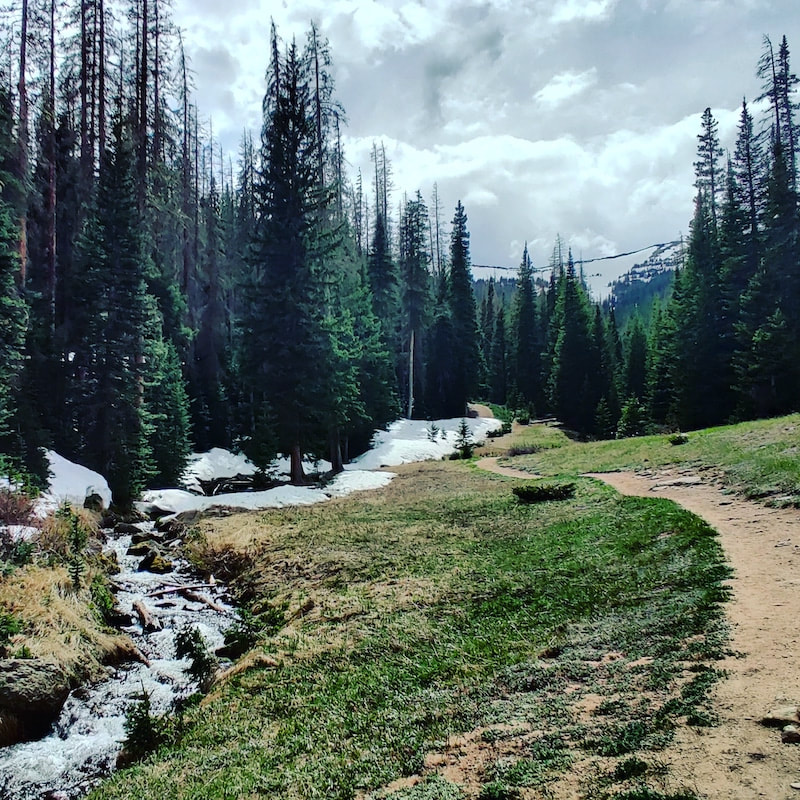
This land is my land – and yoursBy Barb Boyer Buck Yesterday, Rocky Mountain National Park opened for the first time since it was closed to the public on March 20 in consideration of the national COVID19 crisis. But right up until yesterday (and during the day), there were rapid changes in both RMNP and Town of Estes Park policies, which made things a bit confusing.  Bear Lake with Longs Peak For the past 25 years I’ve lived in Estes Park and generally accessed the Rocky via either the Fall River or Beaver Meadows entrances, both located just west of town. These entrances handle most of the vehicles entering the Park; in the winter months, it can be a factor of 30 times more vehicles entering the Park from this side of the Continental Divide. Just to illustrate this dichotomy: in July, 2019 (the Park’s highest visitation month that year) more than 210,500 vehicles entered Rocky from the vehicle entrances near Estes Park, compared to about 61,000 vehicles on the west entrance, at Grand Lake.  Click for a larger image As the dust begins to settle on changing regulations at both the local and federal level, it appears that as of June 4, 2020, Rocky will host only 4,800 vehicles per day from any entrance, or 148,800 vehicles for the entire month, a little more than half of the vehicles that cruised through the Park’s gates last year in July, the year’s highest visitation month. (For the purposes of this comparison, vehicle counts at access points that don’t require an entrance fee are being left out, ie, Lily Lake, Longs Peak, and Lumpy Ridge on the east side.)  Purple Fringe wildflower Rocky Mountain National Park publishes vehicle counts on their website for all of these access points going back more than 20 years. 2020’s timed-entry for July will keep vehicles at 42,200 less than what was counted in 1996 for that month, according to RMNP.  Upper Fall River Wow. I’ve lived in Estes Park since then and I am absolutely thrilled about this! But I also realize as a National Park, this land belongs to every citizen of this country and access needs to be granted to everyone on a fair basis.  Flowering Oregon grape Park officials recognize this too; thus, the introduction of reservation system for entry into RMNP. At an Estes Park Town Board meeting on May 12, Rocky Mountain National Park officials presented the plan for a timed-entry system to be implemented with the opening of the Park to the public on May 27. Federal approval for the timed-entry plan did not come through until yesterday, but the Park opened anyway so I started my visit before 8 a.m., remembering how RMNP experiences so much congestion this time of year.  Puffball Mushrooms I took along a friend who is relatively new to the area and hadn’t seen much of Rocky previously. We ended up spending about eight hours in RMNP, touring all the areas we could access by car. We took a few short hikes, too – such as around the Bear Lake Nature Trail. Pro tip, especially if you have children: the Rocky Mountain Conservancy publishes a guide book to interpret the bear-paw trail markers around the lake: https://rmconservancy.org/product/bear-lake-nature-trail/. 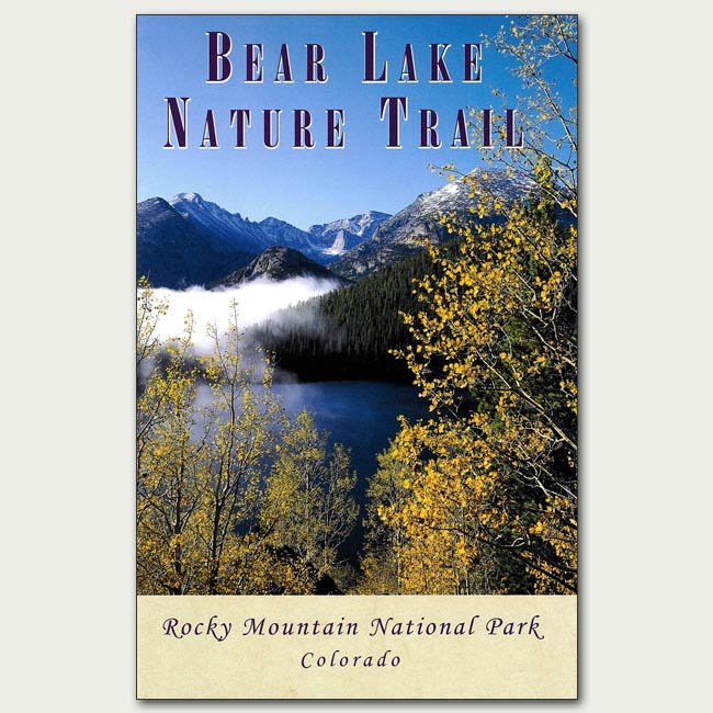 Joe and I entered RMNP from the Fall River entrance station. Only one gate was open, but the line to get in was relatively short. There were two rangers at the entrance, both wearing masks. They were friendly and encouraging, and thanked us for visiting.  Pussytoes Currently, the Aspen Glen Campground (the first destination after entering the Park from that entrance) is closed; there are no plans yet to open this campground this summer. We continued to Sheep Lakes – a popular spot for Big Horn Sheep during the spring and early summer months. Unfortunately, we didn’t see any that early in the day.  Stonecrop Next, was the entrance to Endovalley and the Alluvial Fan created by the Lawn Lake Flood of 1982. Prior to the area being established as a National Park, a group of farmers from Loveland dammed the small lake in the upper portions of the Roaring River Valley. This valley descends 2500 feet in just six miles and when the long-forgotten dam finally deteriorated enough to fail, it resulted in a spectacular fan of rock debris, creating what is today an amazing waterfall. There are several indications of that flood still remaining at the site.  Mossy rock outcrop The road to Endovalley is closed to vehicles, but foot and bicycle traffic to the picnic grounds and Old Fall River Road is still allowed. I became a little anxious about this time; it was already after 10 a.m. and we hadn’t yet seen Bear Lake. As a local I have seen the Bear Lake Corridor become more and more crowded with every visit; parking at Bear Lake is usually completely full well before noon. Over the years, increasing visitation compelled Park officials to initiate several protocols: a sign before you head up telling you if the parking lot is full and several shuttle busses and shuttle-bus stops along the way.  Horseshoe Falls at the Alluvial Fan The bottlenecking at this location is caused by Bear Lake Road itself - it dead ends at Bear Lake after traveling through Moraine Park. The traffic was relatively light on the road; the shuttle stops were empty (as were the shuttle busses driving by) and it was easy to get a parking spot right at Bear Lake. The lake is located at nearly 9,500 feet above sea level in the sub-alpine region with glorious views of the Continental Divide, including the back side of Longs Peak. Yesterday, even though visitation was a fraction of what it usually is this time of year, it was still hosting lots of families and groups and there was a considerable amount of screeching and yelling, making it sound more like an amusement park than a national park. Masks were required at this location if it became impossible to stay at least six feet away from others (and it was). Unfortunately, quite a few groups and individuals did not observe this rule.
On the way back from Bear Lake we stopped where we could along the road. The Glacier Gorge parking area (that leads to Alberta Falls) was completely full, so we didn’t stop there. We walked around Sprague Lake, which was also moderately populated with people; some with masks, most without. The Glacier Basin Campground and road are closed at this time. Hollowell Park was open and the trail looked great – we didn’t hike much there because it looked like a storm was moving in and the trailhead leads through lots of meadows.
We stopped at the Moraine Park Discovery Center (also currently still closed) and were greeted with amazing views across the moraine floor. The new leaves on the aspen trees were lime green and many elk were brooding – it’s almost calving season.
Then, it was on to Trail Ridge Road. This is also US Highway 34, making it the highest paved thoroughfare in the United States. Currently, Trail Ridge Road is open to Rainbow Curve, just below tree line which is a little more than 11,000 feet in elevation in Rocky. Above this line, trees cannot tolerate the temperatures and weather to survive. At or near this line, especially on Trail Ridge Road, you will encounter trees that are some of the oldest organisms in Colorado – more than 400 years old, in some cases. They are also the most curious trees you’ll see – stunted and short, some twisted from the wind, with limbs growing only on the leeward side of the trunk. The side that faces the harsh elements are polished nearly smooth, like driftwood.
On the way up, we stopped at Hidden Valley - a historical site that once hosted a small, fully-developed day skiing resort just below the Continental Divide. The ski lifts have been removed, and safety fencing was installed after the resort’s closure in 1991. But yesterday, we observed several skiers, hiking up to the Divide to ski down some of the slopes that still had snow.
All in all, it was a perfect day! But when we got back into town (and cell reception), we discovered the mask ordinance in downtown Estes Park, which supplements regulations still in place for Larimer County, was revoked. This emergency ordinance was enacted on May 1 through a special meeting and essentially stated that mask must be worn throughout the downtown Estes Park corridor (even outdoors).
This ordinance caused some backlash from the downtown business owners who were having a hard-enough time controlling mask use inside of their businesses (as per county order). Visitors who were accustomed to strolling around downtown, eating and drinking various foods and snacks, were not thrilled, either. Also, during our day in the Park, the timed-entry reservation system for Rocky was finally approved by the Secretary of the Interior and will be implemented starting June 4. This means that between the hours of 6 a.m. and 5 p.m., a reservation must be held to access the Park. The complete description of the timed-entry reservations system is linked to from our site, https://www.rockymountaindayhikes.com/index.html. The reservation system is up and running as of today at https://www.recreation.gov/ticket/facility/300013 This means reservations to visit Rocky Mountain National Park from June 4-July 31 can now be made on this site. Pro-tip: if you are an interagency pass holder (America the Beautiful pass, allowing you to access any federally-managed land; a RMNP annual pass holder, or a Golden Access (lifetime pass holder for those 62 or older), you still need to make a reservation. All reservations will include a $2 reservation fee, even if you possess a pre-paid access pass. For those who need to access Trail Ridge Road for work or other non-recreational purposes, the Park will be issuing a $25 pass. Information about this can also be found on the RMNP website. We are still awaiting clarification on several contingencies that may arise, but at this point, I am completely in support of the timed-entry reservation system. I am thrilled to be able to experience this beautiful place without the congestion and delays caused by the more than 4.5 million visitors who visit RMNP annually, now the third most-visited national park in the nation. But I am concerned the Town repealed its downtown corridor mask ordinance. Most of these millions of visitors come through Estes Park, and at this time, we only have 23 hospital beds. The average age in Estes Park is 59; but we are a popular retirement part-time residence, so this this age demographic is a bit misleading. Our community swells in the summer months, with the snowbirds (second-home owners who only live in the area during summer). Snowbirds are not counted in age or population demographics and tend to be elderly. Rocky Mountain National Park belongs to every citizen in this country and hosts millions of citizens from all over the world. One hundred years ago, the last time a worldwide pandemic affected us, this area was sparsely populated and hosted hundreds – not millions - of visitors. A large-scale reinfection in this area, which to date has had very few confirmed cases, may force our governor to request NPS to close Rocky again; or even close down all in-store shopping in Estes Park. I believe if those who visit this area do so after careful planning, everyone will experience a less hectic and more enriching experience than has been possible for more than 20 years. We will be pleased to help welcome you to your Rocky Mountain National Park, one of the most beautiful places in the world.
0 Comments
Having Rocky Mountain National Park closed has pushed the rocky mountain day hiker further east into the Roosevelt National Forest. That’s actually just fine, because at this time of year hiking east of the National Park is preferable. Not only is this area further east, but it’s also lower elevation. That is to say, this is where springtime in the Rockies starts. Although I haven’t been in The Park recently, I am certain there is still lots of snow in there and most of the main trails are not yet cleared, although maybe some of the lower Montane trails are. If the boundaries of Rocky had been established more on an ecological lines, it’s likely that this area, known as the Foothills Life Zone, would have been included all the way east to the high plains. So we could say the trails in Roosevelt National Forest are part of the Rocky Mountain Ecological Park, if such a Park existed. And there are a number of good representative trails to hike in this region during the spring months.
hillside. It’s about a 1000’ ft elevation gain through south-facing forest terrain in the first mile. Pretty much just straight up. But, eventually the terrain levels out and at the same time the trees end. Now the terrain is like a low-elevation grassy, rolling tundra. The views are right into Rocky Mountain National Park and it becomes clear, there’s still plenty of snow to melt out of the Park! Most of it will melt over the next month. It appears fire has passed through this rounded ridge top where we are hiking and the hiking is superlative, especially if you navigate over the rocky spine of the ridge.
I highly recommend exploring the eastern portion of the Rocky Mountain Ecological area of Roosevelt National Forest during the remaining month of May. Then you can follow spring as it ascends into the National Park all the way to the Alpine Zone.  Golden Banner signals the start of hiking season
|
"The wild requires that we learn the terrain, nod to all the plants and animals and birds, ford the streams and cross the ridges, and tell a good story when we get back home." ~ Gary Snyder
Categories
All
“Hiking -I don’t like either the word or the thing. People ought to saunter in the mountains - not hike! Do you know the origin of the word ‘saunter?’ It’s a beautiful word. Away back in the Middle Ages people used to go on pilgrimages to the Holy Land, and when people in the villages through which they passed asked where they were going, they would reply, A la sainte terre,’ ‘To the Holy Land.’ And so they became known as sainte-terre-ers or saunterers. Now these mountains are our Holy Land, and we ought to saunter through them reverently, not ‘hike’ through them.” ~ John Muir 
|