|
RMNP Press Release
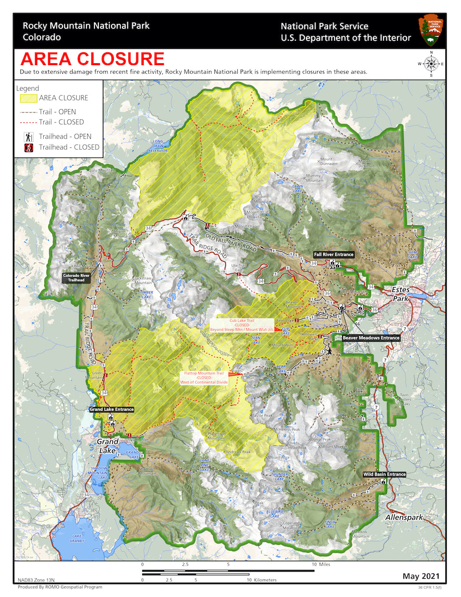
Bear Lake Road in Rocky Mountain National Park reopened today after being closed since October 22, due to the East Troublesome Fire. All areas and trails east of Bear Lake Road have reopened. Most areas west of Bear Lake Road remain closed including the Moraine Park Road at the junction of Bear Lake Road and the Moraine Park Campground. Trails that remain closed include the Fern Lake Trail, Cub Lake Trail, the Mill Creek Basin, Hollowell Park, and Bierstadt Trail. The trail system in the Bear Lake area has reopened. The Flattop Trail is open to the summit of Flattop Mountain but is closed past this point to the west of the Continental Divide. The Odessa/Fern Lake Trail is closed at the Odessa/Flattop Trail junction. The Bierstadt Trail is also closed at the Bear Lake/Bierstadt Trail junction. The west side of Rocky Mountain National Park remains closed past the Grand Lake Entrance as does the North Inlet Trail and the Sun Valley Trail, due to the level of fire impacts and ongoing safety assessments. Additional areas that will remain temporarily closed to park visitors on the east side of the park include Upper Beaver Meadows Road, the North Boundary Trail, the North Fork Trail, and Mummy Pass, Stormy Pass, Commanche Peak and Mirror Lake Trails. Park staff will continue to assess these areas for fire activity, safety and downed trees, being mindful of high winds that occur this time of year causing more trees to fall. On Wednesday, October 21, the East Troublesome Fire ran approximately 18 miles before it moved into the west side of Rocky Mountain National Park, and then spotted approximately 1.5 miles from the head of Tonahutu Creek on the west side of the Continental Divide to the head of Spruce Creek on the east side of the Continental Divide. Rapid evacuations took place in Grand Lake on October 21. Evacuations for the majority of the Estes Valley were implemented on October 22, as weather predictions forecast major winds on the night of October 23 through October 24 pushing the fire further to the east. Firefighting actions and favorable weather on October 24 and 25, helped halt the major movement of the East Troublesome and Cameron Peak Fires. Approximately 30,000 acres or 9 percent of Rocky Mountain National Park has been impacted by the East Troublesome and Cameron Peak Fires. Rocky Mountain National Park’s non-profit partner, The Rocky Mountain Conservancy, is accepting donations to support the park’s future restoration efforts from this season’s fires https://rmconservancy.org/join-or-give/donate/ For information on the East Troublesome Fire visit https://inciweb.nwcg.gov/incident/7242/ For information on the Cameron Peak Fire visit https://inciweb.nwcg.gov/incident/6964/ For further information about Rocky Mountain National Park, please visit ww.nps.gov/romo or contact the park’s Information Office at 970-586-1206. This information including the map can be found at the park's website at: https://www.nps.gov/romo/learn/fire-information-and-regulations.htm
0 Comments
RMNP Press Release
Today, Tuesday, November 17, Trail Ridge Road in Rocky Mountain National Park officially closed for the season to through travel. Currently Trail Ridge Road is open to Many Parks Curve on the east side of the park and to the Grand Lake Entrance on the west side of the park, due to safety issues related to the East Troublesome Fire impacts along that lower western portion of Trail Ridge Road. Trail Ridge Road was not designed to be an all season road, with 11 miles above 11,500 feet, few guardrails and no shoulders. Winter conditions of drifting snow, high winds and below freezing temperatures often occur above 10,000 feet. Trail Ridge Road normally opens the last week in May, weather permitting. This year Trail Ridge Road opened on June 4. Old Fall River Road has also closed for the season. Trail Ridge Road and Old Fall River Road will remain open to bicycles and leashed pets through November 30, re-opening on April 1, except during road maintenance operations and emergency closures as posted. Cyclists and pet owners may utilize the roads at their own risk. On December 1, both of these roads will revert to "winter trail status" which means that bicycles and leashed pets are no longer permitted beyond the closed gates but pedestrians are. At this time, Trail Ridge Road is closed between the Colorado River Trailhead and Grand Lake Entrance to all uses. For more information about Rocky Mountain National Park, please visit www.nps.gov/romo or call the park’s Information Office at (970) 586-1206. RMNP Press Release
Additional areas in Rocky Mountain National Park will reopen after being closed since October 22, due to the East Troublesome Fire. Saturday, November 14, US 36 past the Beaver Meadows Visitor Center to Deer Ridge Junction will reopen, including the Beaver Meadows Entrance Station. On the east side of the park Trail Ridge Road is open to Many Parks Curve. The ongoing road construction project between Beaver Meadows Entrance Station and Deer Ridge Junction will continue again on Monday, November 16; visitors should expect up to 20-minute delays from 7 am to 5 pm. The East Inlet Trail and the East Shore Trail on the west side of Rocky Mountain National Park have reopened. The west side of Rocky Mountain National Park remains closed past the Grand Lake Entrance as does the North Inlet Trail and the Sun Valley Trail, due to the level of fire impacts and ongoing safety assessments. Areas that will remain temporarily closed to park visitors on the east side of the park include Bear Lake Road, Upper Beaver Meadows Road, the North Boundary Trail, the North Fork Trail, and Mummy Pass, Stormy Pass, Commanche Peak and Mirror Lake Trails. Park staff will continue to assess these areas for fire activity, safety and downed trees, being mindful of high winds that occur this time of year causing more trees to fall. On Wednesday, October 21, the East Troublesome Fire ran approximately 18 miles before it moved into the west side of Rocky Mountain National Park, and then spotted approximately 1.5 miles from the head of Tonahutu Creek on the west side of the Continental Divide to the head of Spruce Creek on the east side of the Continental Divide. Rapid evacuations took place in Grand Lake on October 21. Evacuations for the majority of the Estes Valley were implemented on October 22, as weather predictions forecast major winds on the night of October 23 through October 24 pushing the fire further to the east. Firefighting actions and favorable weather on October 24 and 25, helped halt the major movement of the East Troublesome and Cameron Peak Fires. Park visitors should be aware of smoke, wind, weather and fire conditions. Approximately 30,000 acres or 9 percent of Rocky Mountain National Park has been impacted by the East Troublesome and Cameron Peak Fires. Rocky Mountain National Park’s non-profit partner, The Rocky Mountain Conservancy, is accepting donations to support the park’s future restoration efforts from this season’s fires https://rmconservancy.org/join-or-give/donate/ For information on the East Troublesome Fire visit https://inciweb.nwcg.gov/incident/7242/ For information on the Cameron Peak Fire visit https://inciweb.nwcg.gov/incident/6964/ For further information about Rocky Mountain National Park, please visit www.nps.gov/romo or contact the park’s Information Office at 970-586-1206. RMNP Press Release
The Thompson Zone of the East Troublesome Fire, on the east side of the Continental Divide within Rocky Mountain National Park, was previously managed by the Cameron Peak Fire team and has been transitioned back to the East Troublesome Fire team. The East Troublesome Fire is currently being managed by a Type 3 Incident Management Team. The Thompson Zone is being managed by a Division Group Supervisor, located within the park, who reports to the Incident Commander. The recent snow has diminished much of the smoke producing heat coming from the interior of the fire within Rocky Mountain National Park. Prior to this recent snow, the only heat observed was high on Beaver Mountain and on the back side of Mount Wuh, in steep terrain with beetle kill, snags and dead and down trees. These areas have been tested by high winds and the fire has not moved. The fire is secure on the eastern flanks where firefighters have had access to mop up heat. Fire managers continue to assess weather and fire danger calculations and there is currently no threat from the fire to move toward the Estes Valley. Approximately 30,000 acres, or 9 percent of Rocky Mountain National Park has been impacted by the East Troublesome and Cameron Peak Fires. Some areas of the park remain closed https://www.nps.gov/romo/learn/fire-information-and-regulations.htm Rocky Mountain National Park’s non-profit partner, The Rocky Mountain Conservancy, is accepting donations to support the park’s future restoration efforts from this season’s fires https://rmconservancy.org/join-or-give/donate/ For information on the East Troublesome Fire visit https://inciweb.nwcg.gov/incident/7242/. For information on the Cameron Peak Fire visit https://inciweb.nwcg.gov/incident/6964/. RMNP press release
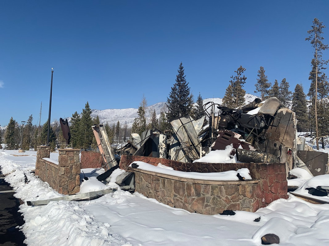
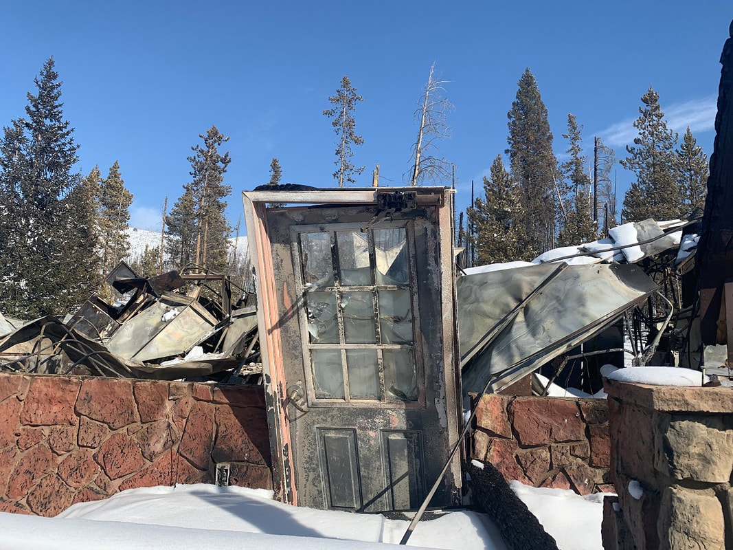
The two largest wildfires in Colorado’s history continue to burn into early November. While the bulk of these fires are on lands surrounding Rocky Mountain National Park, nearly 30,000 acres have burned within the park’s boundary. “This has been a challenging fire year for us and for all Coloradoans,” said park superintendent Darla Sidles. “Our staff are part of these communities, and our hearts go out to all our friends, family, and neighbors who have suffered and lost as a result of these fires.” There have been impacts within the park as well. When the East Troublesome Fire grew over 100,000 acres in one day and swept through a portion of the park, a number of park structures were lost. Some of the structures that burned in the fire include the park’s Trails and Tack Barn and all its contents, the Grand Lake entrance station office, sparing the entrance kiosks themselves, the historic Onahu Lodge and Green Mountain cabins and the Harbison Meadows vault toilet facility. The 4 bay garage structure at Trail River Ranch and all its historic contents within were lost. The main park housing area, the Kawuneeche Visitor Center, the Trail River Ranch main building and Buckaroo Barn were all spared. At this time, in some remote locations, the fires are still active, and a number of hazards persist. Park staff cannot get into all areas for a full structure assessment. As the fires are contained and hazards mitigated, staff will provide a more thorough assessment of all the structures that have sustained loss and damage. “It pains our hearts to see the loss of cherished structures like the Green Mountain cabins and Onahu Lodge, located along Trail Ridge Road in the Kawuneeche Valley,” added Sidles. “Both were eligible for the National Register of Historic Places for their rustic design and association with early 20th century development of ranching and resort industries. But more importantly they represented an important part of our shared history and culture and were cherished landmarks. They were also where many of our seasonal staff were housed.” On the east side of the park, the historic Fern Lake Backcountry Patrol Cabin was lost. “The Fern Lake Backcountry cabin was constructed in 1925. It’s the oldest structure that burned. In 95 years, countless rangers, wilderness crews, trails crews, biologists, and search and rescue operations have been based and supported out of this cabin,” said Sidles. One success the park has seen in the wake of these large wildfires lies in the fire mitigation and fuels management efforts over the last two decades. “It was recognized over 20 years ago that Estes Park and other communities adjacent to the park were at risk from wildfire,” said Fire Management Officer Mike Lewelling. “Over that time, there was a realization that wildfires are getting larger nationwide, fire seasons are getting longer and to make matters worse, the mountain pine beetle outbreak created a fuels profile that is very volatile.” The park’s fire program has engaged in fuels management practices for a while and over the last five years have put together a more comprehensive fuels program with the goal of creating a "catcher’s mitt" around Estes Park and other areas of the park boundary near Allenspark and Lily Lake. More aggressive fuels reduction projects including thinning and prescribed fire have been implemented along the park boundary; along roads and trails; and around park buildings, housing, and other infrastructure. “It was widely accepted that these fuels treatments on their own would probably not stop a fire, but they give firefighters a chance,” added Lewelling. “On the west side of the park, fuels treatments were instrumental to protect the Kawuneechee housing and visitor center. On the east side, fuels treatments slowed fire spread, reduced tree torching which causes spot fires, and reduced the intensity allowing firefighters to be more aggressive and go direct.” The fires burned in spruce-fir and lodgepole pine forests with a high-degree of beetle-killed trees, ponderosa pine woodlands, and upland meadows. Due to the extreme dry conditions, the fire also burned through ecosystems that would otherwise be expected to buffer fire effects such as some of the wetlands, riparian areas, and aspen groves. While fire is a natural process, natural recovery could be hampered by changed environmental conditions and the enhanced spread of exotic plants. In addition, before plant cover re-establishes, more water runoff is anticipated, which could affect downstream ecosystems, infrastructure, and water systems. Rocky Mountain National Park will prepare a Burned Area Emergency Response (BAER) Plan which will assess the burned area and potential for post-fire disturbance and recommend activities to mitigate these impacts when possible. The park also will pursue research and monitoring opportunities to track and understand post-fire effects and recovery. “We will continue to assess additional areas in the park that we can reopen when it is safe to do so,” said Sidles. “The natural resources will recover with new life sprouting up in the fire’s footprint, and we will move forward and continue to do our best to manage Rocky Mountain National Park to preserve the natural and cultural resources for the enjoyment, education, and inspiration of this and future generations.” For the most up-to-date information on the East Troublesome Fire visit https://inciweb.nwcg.gov/incident/7242/. For the most up-to-date information on the Cameron Peak Fire visit https://inciweb.nwcg.gov/incident/6964/. RMNP News Release
Rocky Mountain National Park is open, but many areas remain closed. Before you plan your trip, check for area closures here: https://www.nps.gov/.../fire-information-and-regulations.htm RMNP press release
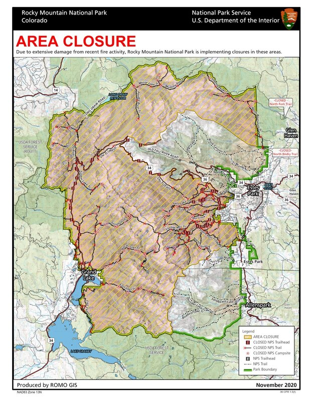
On Friday, November 6, many areas in Rocky Mountain National Park will reopen after being closed since October 22, due to the East Troublesome Fire. Areas that will reopen include roads, parking areas and trails in Wild Basin, Longs Peak, Lily Lake, Twin Sisters, Lumpy Ridge and US 34 through the Fall River Entrance to Many Parks Curve as well as the Endovalley Road. Old Fall River Road will be open to bicycles, leashed pets and walkers. The west side of Rocky Mountain National Park remains closed due to the level of fire impacts and ongoing safety assessments. Areas that remain temporarily closed to park visitors on the east side of the park include US 36 past the Beaver Meadows Visitor Center to Deer Ridge Junction, including the Beaver Meadows Entrance. Bear Lake Road remains closed. The North Boundary Trail, the North Fork Trail, and Mummy Pass, Stormy Pass, Commanche Peak and Mirror Lake Trails remain closed. Park staff will continue to assess these areas for fire activity, safety and downed trees, being mindful of high winds that occur this time of year causing more trees to fall. On Wednesday, October 21, the East Troublesome Fire ran approximately 18 miles before it moved into the west side of Rocky Mountain National Park, and then spotted approximately 1.5 miles from the head of Tonahutu Creek on the west side of the Continental Divide to the head of Spruce Creek on the east side of the Continental Divide. Rapid evacuations took place in Grand Lake on October 21. Evacuations for the majority of the Estes Valley were implemented on October 22, as weather predictions forecast major winds on the night of October 23 through October 24 pushing the fire further to the east. Firefighting actions and favorable weather on October 24 and 25 helped halt the major movement of the East Troublesome and Cameron Peak Fires. Park visitors should be aware of smoke, wind, weather and fire conditions. For the most up-to-date information on the East Troublesome Fire visit https://inciweb.nwcg.gov/incident/7242/ For the most up-to-date information on the Cameron Peak Fire visit https://inciweb.nwcg.gov/incident/6964/ For further information about Rocky Mountain National Park, please visit www.nps.gov/romo or contact the park’s Information Office at 970-586-1206. |
RMNP UpdatesPress Releases from Rocky Mountain National Park and the Rocky Mountain Conservancy.
Archives
September 2025
|
rmnp updates
© Copyright 2025 Barefoot Publications, All Rights Reserved


